Category:Plaza de La Glorieta
Jump to navigation
Jump to search
| Camera location | | View all coordinates using: OpenStreetMap |
|---|
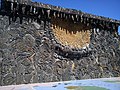
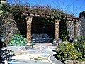
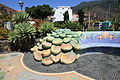
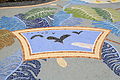
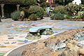
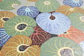
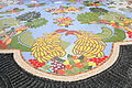
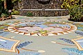
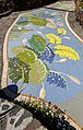
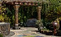
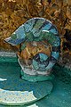
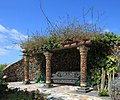
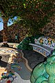
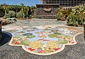
English: Pictures of Plaza de La Glorieta, a park and botanical garden with mosaics by Luis Morera in Las Manchas, a village belongs to the municipalities Los Llanos de Aridane and El Paso, on La Palma, the most north-westerly island of the Canary Islands in Spain. Plaza de La Glorieta is near the streets Camino del Callejón de Las Manchas and Camino Manchas de Abajo
| Upload media | |||||
| Instance of | |||||
|---|---|---|---|---|---|
| Location | Los Llanos de Aridane, La Palma, Atlantic Ocean, international waters | ||||
 | |||||
Subcategories
This category has only the following subcategory.
F
- Flora of Plaza de La Glorieta (34 F)
Media in category "Plaza de La Glorieta"
The following 74 files are in this category, out of 74 total.
-
 D00 341 Plaza de Glorieta.jpg 2,592 × 1,944; 1.81 MB
-
 D00 342 Plaza de Glorieta.jpg 2,592 × 1,944; 1.59 MB
-
 D00 343 Plaza de Glorieta.jpg 2,592 × 1,944; 2.16 MB
-
 D00 344 Plaza de Glorieta.jpg 2,592 × 1,944; 1.35 MB
-
 D00 346 Plaza de Glorieta.jpg 2,592 × 1,944; 2.13 MB
-
 D00 350 Plaza de Glorieta, Fußboden.jpg 2,592 × 1,944; 1.74 MB
-
 I08 875 Plaza de la Glorieta.jpg 4,494 × 2,996; 6.36 MB
-
 I08 876 Plaza de la Glorieta.jpg 4,494 × 2,996; 6.07 MB
-
 I08 877 Plaza de la Glorieta.jpg 4,494 × 2,996; 6.35 MB
-
 I08 878 Plaza de la Glorieta.jpg 4,249 × 2,833; 4.98 MB
-
 I08 879 Plaza de la Glorieta.jpg 4,494 × 2,996; 6.61 MB
-
 I08 880 Monstera.jpg 2,905 × 4,357; 4.98 MB
-
 I08 881 Plaza de la Glorieta.jpg 4,494 × 2,996; 6.74 MB
-
 I08 882 Plaza de la Glorieta.jpg 4,494 × 2,996; 6.02 MB
-
 I08 883 Plaza de la Glorieta.jpg 4,434 × 2,956; 5.64 MB
-
 I08 884 Plaza de la Glorieta.jpg 4,494 × 2,996; 5.44 MB
-
 I08 885 Dachwurz.jpg 4,293 × 2,862; 5.6 MB
-
 I08 886 Blütenstand.jpg 4,249 × 2,833; 3.97 MB
-
 I08 887 Blütenstand.jpg 2,833 × 4,249; 3.31 MB
-
 La Palma - Los Llanos de Aridane - Las Manchas - Plaza de Glorieta 01 ies.jpg 5,616 × 3,744; 17.07 MB
-
 La Palma - Los Llanos de Aridane - Las Manchas - Plaza de Glorieta 03 ies.jpg 5,616 × 3,744; 18.24 MB
-
 La Palma - Los Llanos de Aridane - Las Manchas - Plaza de Glorieta 04 ies.jpg 5,616 × 3,744; 22.75 MB
-
 La Palma - Los Llanos de Aridane - Las Manchas - Plaza de Glorieta 05 ies.jpg 5,616 × 3,744; 20.57 MB
-
 La Palma - Los Llanos de Aridane - Las Manchas - Plaza de Glorieta 06 ies.jpg 5,616 × 3,744; 21.06 MB
-
 La Palma - Los Llanos de Aridane - Las Manchas - Plaza de Glorieta 07 ies.jpg 5,616 × 3,744; 20.01 MB
-
 La Palma - Los Llanos de Aridane - Las Manchas - Plaza de Glorieta 08 ies.jpg 5,616 × 3,744; 22.8 MB
-
 La Palma - Los Llanos de Aridane - Las Manchas - Plaza de Glorieta 09 ies.jpg 5,616 × 3,744; 17.67 MB
-
 La Palma - Los Llanos de Aridane - Las Manchas - Plaza de Glorieta 10 ies.jpg 5,616 × 3,744; 18.4 MB
-
 La Palma - Los Llanos de Aridane - Las Manchas - Plaza de Glorieta 11 ies.jpg 5,616 × 3,744; 18.15 MB
-
 La Palma - Los Llanos de Aridane - Las Manchas - Plaza de Glorieta 12 ies.jpg 5,616 × 3,744; 20.05 MB
-
 La Palma - Los Llanos de Aridane - Las Manchas - Plaza de Glorieta 13 ies.jpg 5,616 × 3,744; 20.88 MB
-
 La Palma - Los Llanos de Aridane - Las Manchas - Plaza de Glorieta 14 ies.jpg 5,616 × 3,744; 19.71 MB
-
 La Palma - Los Llanos de Aridane - Las Manchas - Plaza de Glorieta 15 ies.jpg 5,616 × 3,744; 20.38 MB
-
 La Palma - Los Llanos de Aridane - Las Manchas - Plaza de Glorieta 16 ies.jpg 5,616 × 3,744; 19.18 MB
-
 La Palma - Los Llanos de Aridane - Las Manchas - Plaza de Glorieta 17 ies.jpg 5,616 × 3,744; 17.7 MB
-
 La Palma - Los Llanos de Aridane - Las Manchas - Plaza de Glorieta 18 ies.jpg 5,616 × 3,744; 21.01 MB
-
 La Palma - Los Llanos de Aridane - Las Manchas - Plaza de Glorieta 19 ies.jpg 3,744 × 5,616; 19.98 MB
-
 La Palma - Los Llanos de Aridane - Las Manchas - Plaza de Glorieta 20 ies.jpg 3,744 × 5,616; 20.28 MB
-
 La Palma - Los Llanos de Aridane - Las Manchas - Plaza de Glorieta 21 ies.jpg 3,744 × 5,616; 18.93 MB
-
 La Palma - Los Llanos de Aridane - Las Manchas - Plaza de Glorieta 22 ies.jpg 5,616 × 3,744; 21.72 MB
-
 La Palma - Los Llanos de Aridane - Las Manchas - Plaza de Glorieta 23 ies.jpg 5,616 × 3,744; 19.68 MB
-
 La Palma - Los Llanos de Aridane - Las Manchas - Plaza de Glorieta 24 ies.jpg 5,616 × 3,744; 21.18 MB
-
 La Palma - Los Llanos de Aridane - Las Manchas - Plaza de Glorieta 25 ies.jpg 3,744 × 5,616; 18.3 MB
-
 La Palma - Los Llanos de Aridane - Las Manchas - Plaza de Glorieta 26 ies.jpg 5,616 × 3,744; 20.62 MB
-
 La Palma - Los Llanos de Aridane - Las Manchas - Plaza de Glorieta 27 ies.jpg 5,616 × 3,744; 22.57 MB
-
 La Palma - Los Llanos de Aridane - Las Manchas - Plaza de Glorieta 28 ies.jpg 5,616 × 3,744; 21.61 MB
-
 La Palma - Los Llanos de Aridane - Las Manchas - Plaza de Glorieta 29 ies.jpg 5,616 × 3,744; 21.3 MB
-
 La Palma - Los Llanos de Aridane - Las Manchas - Plaza de Glorieta 30 ies.jpg 5,616 × 3,744; 20.37 MB
-
 La Palma - Los Llanos de Aridane - Las Manchas - Plaza de Glorieta 31 ies.jpg 5,616 × 3,744; 20.34 MB
-
 La Palma - Los Llanos de Aridane - Las Manchas - Plaza de Glorieta 32 ies.jpg 3,744 × 5,616; 18.24 MB
-
 La Palma - Los Llanos de Aridane - Las Manchas - Plaza de Glorieta 33 ies.jpg 5,616 × 3,744; 20.49 MB
-
 La Palma - Los Llanos de Aridane - Las Manchas - Plaza de Glorieta 34 ies.jpg 5,616 × 3,744; 16.81 MB
-
 Lapalma plazalaglorietta 200607010011.jpg 4,590 × 792; 1.07 MB
-
 Las Manchas P1450169.jpg 4,000 × 2,672; 5.92 MB
-
 Plaza de la Glorieta - Las Manchas 01.jpg 5,955 × 3,835; 15.94 MB
-
 Plaza de la Glorieta - Las Manchas 02.jpg 5,851 × 3,901; 20.1 MB
-
 Plaza de la Glorieta - Las Manchas 03.jpg 4,000 × 6,000; 14.22 MB
-
 Plaza de la Glorieta - Las Manchas 04.jpg 3,485 × 5,460; 16.45 MB
-
 Plaza de la Glorieta - Las Manchas 05.jpg 5,592 × 3,456; 16.91 MB
-
 Plaza de la Glorieta - Las Manchas 06.jpg 3,856 × 5,784; 15.34 MB
-
 Plaza de la Glorieta - Las Manchas 07.jpg 4,000 × 6,000; 14.98 MB
-
 Plaza de la Glorieta - Las Manchas 08.jpg 6,000 × 4,000; 17.24 MB
-
 Plaza de la Glorieta - Las Manchas 09.jpg 5,699 × 2,979; 14.12 MB
-
 Plaza de la Glorieta - Las Manchas 1.jpg 3,799 × 3,160; 8.68 MB
-
 Plaza de la Glorieta - Las Manchas 10.jpg 5,602 × 3,735; 18.53 MB
-
 Plaza de la Glorieta - Las Manchas 11.jpg 3,937 × 5,906; 13.42 MB
-
 Plaza de la Glorieta - Las Manchas 12.jpg 6,000 × 4,000; 19.48 MB
-
 Plaza de la Glorieta - Las Manchas 13.jpg 6,000 × 4,000; 20.49 MB
-
 Plaza de la Glorieta - Las Manchas 14.jpg 5,714 × 3,809; 15 MB
-
 Plaza de la Glorieta - Las Manchas 15.jpg 4,000 × 6,000; 18.56 MB
-
 Plaza de la Glorieta - Las Manchas 16.jpg 5,990 × 3,828; 16.24 MB
-
 Plaza de la Glorieta - Las Manchas 17.jpg 5,484 × 3,826; 18.05 MB
-
 Plaza de la Glorieta - Las Manchas 18.jpg 6,000 × 4,000; 16.18 MB
-
 Plaza de La Glorieta.JPG 3,888 × 2,592; 2.74 MB


