Category:Portolan charts
Jump to navigation
Jump to search
- (en) Portolan chart
- (ca) Cartografia portolana
- (de) Portolan
- (el) Λιμενοδείκτης
- (es) Portulano
- (fr) Portulan
- (he) פורטולאנו
- (hu) Portolántérkép
- (is) Portolano kort
- (it) Portolano
- (la) Portolani
- (lt) Portulanas
- (pl) Portolan
- (pt) Portulano
- (ru) Портулан
- (tr) Portolan haritası
English: Portolan charts are navigational maps based on realistic descriptions of harbours and coasts. They were first made in the 1300s in Genoa, Venice and Mallorca. With the advent of the Age of Discovery, they were considered State secrets in Portugal and Spain, very valuable in the description of Atlantic and Indian coastlines for newcomer English and Dutch raiding, and later trading, ships. The word portolan comes from the Italian adjective portolano, meaning "related to ports or harbours."
A link to a recent presentation about the Portolan Chards can be found on the Dutch Wiki-page about this subject.
Français : Les Portulans sont des cartes de navigation maritime basées sur des descriptions visuelles de ports et de côtes. Les premières semblent avoir été réalisées à la fin du XIIIème siècle et au début du XIVème siècle à Gênes, à Venise et à Majorque. À l'époque des Grandes Découvertes, elles étaient considérées comme secrets d'Etat au Portugal et en Espagne, en raison de leur grande valeur pour les navires d'exploration, puis de commerce, des puissances maritimes émergentes comme les Pays-Bas ou l'Angleterre. (Le mot "portulan" provient de l'adjectif italien portolano, qui signifie relatif aux ports).
| Upload media | |||||
| |||||
Un lien vers une présentation récente des portulans peut être trouvé sur cette Wiki-page hollandaise traitant du sujet.
Subcategories
This category has the following 11 subcategories, out of 11 total.
A
- Atlas Miller (42 F)
C
L
P
- Portolan charts (reverse sides) (43 F)
- Portolans (1 F)
Q
- Queen Mary Atlas (5 F)
R
- Ruta TelDe (10 F)
Media in category "Portolan charts"
The following 81 files are in this category, out of 81 total.
-
 1325 Dalorto Bulgaria.png 1,366 × 768; 2.14 MB
-
 1385 Soler BG Flag.png 431 × 743; 556 KB
-
 1426 Battista Beccario BG Flag.png 289 × 316; 232 KB
-
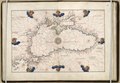
 14th century Portolan chart of the Mediterranean and the Black Sea.tif 5,486 × 4,009; 62.94 MB
-
 1519 Portolan chart of the Mediterranean Sea by Lopo Homem - Atlas Miller.jpg 5,905 × 3,097; 3.94 MB
-
 1519 Portolan chart of the Mediterranean Sea by Lopo Homem from Atlas Miller.jpg 18,767 × 9,834; 35.89 MB
-
 1540s Portolan charts - Atlas nauticus by Battista Agnese.pdf 1,129 × 1,462, 33 pages; 16.28 MB
-
 1544 Portolan chart of the Black Sea and the Sea of Marmara by Battista Agnese.tif 5,712 × 3,952; 64.61 MB
-
 1547 Portolan chart of the Mediterranean Sea by Vesconte Maggiolo.jpg 11,492 × 7,786; 10.13 MB
-
 1550 Portolan chart of the Mediterranean Sea and the Black Sea.jpg 16,161 × 8,710; 17.93 MB
-
 1550s Portolan charts by Battista Agnese.pdf 1,162 × 1,597, 18 pages; 51 MB
-
 Sebastião Lopes 1575.jpg 2,232 × 3,100; 4.32 MB
-
 1650 Portolan chart of the Mediterranean Sea by François Ollive second version.jpg 5,764 × 3,520; 3.61 MB
-
 1650 Portolan chart of the Mediterranean Sea by François Ollive.jpg 5,724 × 4,016; 4.29 MB
-
 17th century Portolan chart of the Mediterrenean Sea.jpg 5,749 × 3,967; 3.36 MB
-
 2-ruta TeIDe.png 720 × 1,135; 1.66 MB
-
 Age of Exploration-map.jpg 424 × 544; 40 KB
-
 Anglo-Saxon Tradition.jpg 1,407 × 672; 186 KB
-
 Anonymous chart Valladolid 16 century.jpg 1,973 × 1,463; 2.35 MB
-
 Banet Panades Nautical chart Mediterranean 1557.jpg 3,008 × 2,000; 2.33 MB
-
 Biblioteca da Marinha, mapa.JPG 995 × 1,174; 176 KB
-

-
 Bodleian Libraries, Formosa Strait by Anon Dutch, early 18th century.jpg 1,000 × 675; 126 KB
-
 Bodleian Libraries, Portolan chart of Gulf of Guinea.jpg 992 × 672; 146 KB
-

-

-

-
-
-

-

-
 Bodleian Libraries, Portolan codex Tyrrhenian Sea the Ligurian Sea.jpg 1,000 × 675; 105 KB
-
-
-
 Bodleian Libraries, Portuguese portolan of the Atlantic 22.jpg 1,000 × 675; 158 KB
-
 Bodleian Libraries, Portuguese portolan of the Atlantic 25.jpg 1,000 × 675; 135 KB
-
 Bodleian Libraries, Portuguese portolan of the Atlantic 35.jpg 672 × 1,000; 146 KB
-
 Bodleian Libraries, Portuguese portolan of the Atlantic 41.jpg 1,000 × 675; 137 KB
-
 Bodleian Libraries, Portuguese portolan of the Atlantic 42.jpg 1,000 × 675; 141 KB
-
 Bodleian Libraries, Portuguese portolan of the Atlantic 47.jpg 672 × 1,000; 140 KB
-
 Bodleian Libraries, Portuguese portolan of the Atlantic 66.jpg 672 × 1,000; 138 KB
-
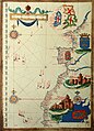
 Bodleian Libraries, Portuguese portolan of the Atlantic.jpg 1,000 × 675; 138 KB
-

-
 Bodleian Libraries, South China Sea and the Gulf of Siam by Joan Blaeu, 1679.jpg 672 × 1,000; 126 KB
-
 Bodleian Libraries, The Java Sea by John Thornton, 1701 57.jpg 1,000 × 675; 126 KB
-
 Bodleian Libraries, The Java Sea by John Thornton, 1701.jpg 1,000 × 675; 120 KB
-

-
 Bordeaux-P1080798.jpg 3,240 × 3,608; 3.76 MB
-
 Callapoda Portolan Chart of Europe 1560.jpg 10,469 × 6,248; 17.15 MB
-
 Cantino west.jpg 1,186 × 1,202; 1.34 MB
-
 Carte de l Ocean Atlantique - A Dieppe Par Guillemme Levasseur, le 12 de Juillet 1601.jpg 6,328 × 4,752; 7.61 MB
-
 Carte Portulan du Maghreb.jpg 1,024 × 1,351; 240 KB
-
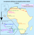 Cartografia XIII-XV a l'Atlàntic.png 733 × 744; 176 KB
-
 Chart of the Black Sea and eastern Mediterranean - Cornaro Atlas (Egerton MS 73, f.3r).jpeg 8,197 × 6,309; 47.69 MB
-
 Colobo.jpg 426 × 480; 83 KB
-
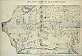
 Development-1300-modern.jpg 1,632 × 3,780; 338 KB
-
 EB 1911 Map Fig 19.png 1,724 × 1,320; 1.59 MB
-
 Fernão Vaz Dourado 1571-1.jpg 3,102 × 2,381; 5.82 MB
-
 Fernão Vaz Dourado 1575-1.jpg 3,195 × 2,406; 5.7 MB
-
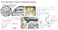
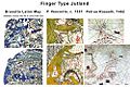 Finger Type Jutland.jpg 1,000 × 667; 129 KB
-
 Gon-Stat3.png 2,076 × 956; 266 KB
-
 Hispaniola .jpg 1,024 × 721; 294 KB
-
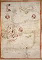
 Iana.png 450 × 618; 544 KB
-
 Italy.gif 350 × 391; 88 KB
-
 Mediterranean and Black Sea and NE Atlantic RMG K1007.jpg 1,280 × 897; 1.6 MB
-
 MS. Douce 391 portolan chart.jpg 675 × 1,000; 280 KB
-
 Norm Portolan Tradition.jpg 1,600 × 843; 205 KB
-
 Pedro Reinel 1485.png 577 × 770; 1.04 MB
-
 Península Ibérica no portolano de Angelo de Conte Freducci (1555).jpg 3,822 × 2,912; 9.53 MB
-
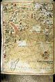
 Portolan 1325 (Angelino Dalorto).jpg 4,972 × 3,404; 4.93 MB
-
 Portolan Atlas of the Mediterranean Sea, Western Europe, and the Northwest Coast of Africa WDL3200.pdf 900 × 1,285, 5 pages; 254 KB
-
 Portolan chart of the Pacific coast from Mexico to northern Chile. LOC 2008628167.jpg 10,638 × 5,030; 5.42 MB
-
 Portolan chart of the Pacific coast from Mexico to northern Chile. LOC 2008628167.tif 10,638 × 5,030; 153.09 MB
-
 Portulanos y cartas de marear-01.png 800 × 2,855; 2.03 MB
-
 Portulanos y cartas de marear-02.png 801 × 2,855; 2.11 MB
-
 Secret Atlas Vers. 1.jpg 1,441 × 1,446; 425 KB
-
 SoOtranto.jpg 1,155 × 1,164; 207 KB
-
 Transmap7.jpg 1,888 × 2,098; 898 KB
-
 Trapobana.png 450 × 252; 254 KB
-
 VOC Octrooigebied 2.jpg 3,000 × 1,978; 663 KB
-
 Voyage of Francisco de Orellana Map by António Pereira 1546.jpg 2,315 × 2,931; 915 KB


.jpg)


.jpeg)


.jpg)
.jpg)


