Category:Reformierte Kirche, Därstetten
Jump to navigation
Jump to search
| Object location | | View all coordinates using: OpenStreetMap |
|---|
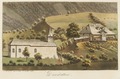
reformed church and former monastery in Därstetten in the canton of Bern, Switzerland   | |||||
| Upload media | |||||
| Instance of |
| ||||
|---|---|---|---|---|---|
| Part of | |||||
| Location | Därstetten, Frutigen-Niedersimmental administrative district, Oberland administrative region, Bern, Switzerland | ||||
| Street address |
| ||||
| Heritage designation | |||||
 | |||||
Media in category "Reformierte Kirche, Därstetten"
The following 8 files are in this category, out of 8 total.
-
 CH-NB - Därstetten - Collection Gugelmann - GS-GUGE-WEIBEL-D-27.tif 5,700 × 3,775, 2 pages; 43.01 MB
-
 Därstetten Reformierte Kirche.JPG 3,200 × 2,133; 6.9 MB
-
 Därstetten, Kirche Schattseite 01.jpg 3,000 × 2,000; 7.43 MB
-
 Därstetten, Kirche Schattseite 02.jpg 2,000 × 3,000; 6.98 MB
-
 Därstetten, Kirche Schattseite 03.jpg 2,000 × 3,000; 5.72 MB
-
 Därstetten, Kirche Schattseite 04.jpg 2,000 × 3,000; 4.54 MB
-
 Därstetten, Kirche Schattseite 05.jpg 2,000 × 3,000; 6.04 MB
-
 Grundriss der Klosterkirche Därstetten.jpeg 640 × 464; 28 KB


