Category:Rias
Saltar para a navegação
Saltar para a pesquisa
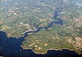
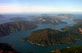
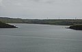
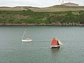
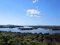
English: A ria is a coastal inlet formed by the partial submergence of an unglaciated river valley. It is a drowned river valley that remains open to the sea. Typically, rias have a dendritic, treelike outline although they can be straight and without significant branches. This pattern is inherited from the dendritic drainage pattern of the flooded river valley. The drowning of river valleys along a stretch of coast and formation of rias results in an extremely irregular and indented coastline. Often, there are islands, which are summits of partially submerged, pre-existing hill peaks. A ria coast is a coastline having several parallel rias separated by prominent ridges, extending a distance inland.
coastal inlet formed by the partial submergence of an unglaciated river valley | |||||
| Carregar ficheiro | |||||
| Áudio da pronúncia | |||||
|---|---|---|---|---|---|
| Subclasse de | |||||
| Diferente de | |||||
| |||||
Subcategorias
Esta categoria contém as seguintes 12 subcategorias (de um total de 12).
Multimédia na categoria "Rias"
Esta categoria contém os seguintes 21 ficheiros (de um total de 21).
-
 Asou-Bay ria coast aerial photograph.JPG 3 487 × 2 609; 3,63 MB
-
 Avilés, ría (2).JPG 3 872 × 2 592; 4,01 MB
-
 Avilés, ría.JPG 3 872 × 2 592; 4,8 MB
-
 Carrick Roads Panorama.jpg 4 632 × 1 019; 2,45 MB
-
 Dart estuary 2.jpg 5 274 × 3 648; 13,52 MB
-
 Kitakami River (false-color) from space.jpg 4 729 × 3 011; 3,79 MB
-
 Pennar Cants - geograph.org.uk - 210539.jpg 640 × 423; 32 kB
-
 Rias senpai.jpg 5 120 × 3 200; 931 kB
-
 Ría de Vigo e islas Cíes.jpg 1 600 × 1 200; 685 kB
-
 Steir of Plobannalec-Lesconil.jpg 1 536 × 2 048; 709 kB
-
 Ster Nibilic.jpg 2 048 × 1 536; 567 kB
-
 Tory Channel Marlborough Sounds.jpg 2 796 × 1 795; 4,08 MB
-
 TruroFalmouthAerial.jpg 1 500 × 2 000; 1,6 MB
-
 Castlehaven - geograph.org.uk - 242683.jpg 640 × 480; 96 kB
-
 Courtmacsherry Bay - geograph.org.uk - 239486.jpg 640 × 468; 62 kB
-
 Courtmacsherry Bay - geograph.org.uk - 239504.jpg 640 × 480; 96 kB
-
 Hazelbeach - geograph.org.uk - 210534.jpg 640 × 480; 43 kB
-
 Pennar Mouth - geograph.org.uk - 210537.jpg 640 × 411; 28 kB
-
 Traffic, Milford Haven - geograph.org.uk - 211348.jpg 640 × 480; 65 kB
-
 View down to Polwheveral Creek - geograph.org.uk - 370832.jpg 640 × 480; 68 kB
-
 ともやま展望台.jpg 1 366 × 1 024; 361 kB

.JPG)


_from_space.jpg)


