Category:Roggestraat 16, Doesburg
Jump to navigation
Jump to search
| Object location | | View all coordinates using: OpenStreetMap |
|---|
 | |||||
| Upload media | |||||
| Instance of |
| ||||
|---|---|---|---|---|---|
| Location | Doesburg, Gelderland, Netherlands | ||||
| Street address |
| ||||
| Located on street | |||||
| Heritage designation |
| ||||
 | |||||
|
This is a category about rijksmonument number 13061
|
| Address |
|
Media in category "Roggestraat 16, Doesburg"
The following 8 files are in this category, out of 8 total.
-
 Doesburg, Netherlands - panoramio (51).jpg 2,048 × 1,148; 417 KB
-
 Doesburg, Netherlands - panoramio - Ben Bender (9).jpg 4,896 × 3,264; 3.2 MB
-
 Evenzijde - Doesburg - 20058330 - RCE.jpg 1,200 × 807; 169 KB
-
 Overzicht - Doesburg - 20058356 - RCE.jpg 792 × 1,200; 167 KB
-
 RM13061 Doesburg - Roggestraat 16.jpg 1,944 × 2,592; 1.37 MB
-
 Voorgevel - Doesburg - 20058355 - RCE.jpg 802 × 1,200; 173 KB
-
 Voorgevels - Doesburg - 20058359 - RCE.jpg 810 × 1,200; 179 KB
-
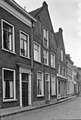
 Zicht in de Roggestraat, richting het zuidwesten - Doesburg - 20425405 - RCE.jpg 986 × 1,200; 249 KB
.jpg)
.jpg)


