Category:SVG political maps of states of South Sudan (location map scheme)
Jump to navigation
Jump to search
Media in category "SVG political maps of states of South Sudan (location map scheme)"
The following 16 files are in this category, out of 16 total.
-
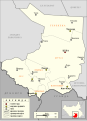
 Al-Buhayrat Administrative Map-sr.svg 1,056 × 694; 191 KB
-
 Al-Wahda Administrative Map-sr.svg 716 × 989; 199 KB
-
 Central Equatoria Administrative Map-sr.svg 611 × 844; 210 KB
-
 Eastern Equatoria Administrative Map-sr.svg 1,117 × 730; 200 KB
-
 Jonglei Administrative Map-sr.svg 1,058 × 693; 259 KB
-
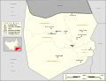 Northern Bahr el Ghazal Administrative Map-sr.svg 1,058 × 810; 180 KB
-
 Sud Sodan - Estats de l'Oèst.svg 1,056 × 695; 191 KB
-
 Sud Sodan - Estats del Nòrd Oèst.svg 1,058 × 810; 164 KB
-
 Sud Sodan - Estats del Nòrd.svg 718 × 988; 325 KB
-
 Sud Sodan - Estats del Sud Oèst.svg 1,055 × 692; 333 KB
-
 Sud Sodan - Estats del Sud Èst.svg 1,117 × 730; 186 KB
-
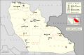
 Sud Sodan - Estats del Sud.svg 611 × 844; 197 KB
-
 Upper Nile Administrative Map-sr.svg 718 × 988; 333 KB
-
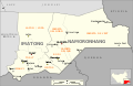
 Warrap Administrative Map-sr.svg 717 × 990; 190 KB
-
 Western Bahr el Ghazal Administrative Map-sr.svg 1,056 × 695; 200 KB
-
 Western Equatoria Administrative Map-sr.svg 1,055 × 692; 342 KB


