Category:Satellite pictures of the Syrian Civil War
Jump to navigation
Jump to search
Media in category "Satellite pictures of the Syrian Civil War"
The following 19 files are in this category, out of 19 total.
-
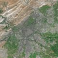 Damascus SPOT 1363.jpg 500 × 500; 134 KB
-
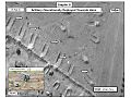
 Syrian Military Units 11-13 February 2012, Az Zabadani, Syria.jpg 800 × 618; 159 KB
-
 SYRIE - Vue satellite au 08 février 2012 - Artillerie syrienne - Carte de 9 positions -.jpg 2,250 × 1,688; 1.39 MB
-

-

-

-

-

-

-
 Artillery Operationally Deployed Towards Homs.JPG 960 × 720; 81 KB
-
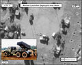 Rocket Launcher Deployed near Homs.jpg 872 × 700; 120 KB
-
 ALEPPO GOVERNORATE GEOGRAPHY.jpg 1,224 × 864; 143 KB
-
 Aleppo-Syria (Satellogic).jpg 7,612 × 5,731; 54.71 MB
-
 Artillery Firing Towards Homs Syria Feb 2012.jpg 2,100 × 1,600; 1.28 MB
-
 Artillery positioned north of Rastan, Syria.jpg 750 × 563; 182 KB
-
 Attack helicopter over the town of Talbisah Syria.jpg 750 × 563; 184 KB
-
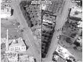
 Syrian Military Units Battle Idlib City Syria March 2012.jpg 962 × 722; 101 KB
-
 SyrianTanks US SatelliteImagery.jpg 720 × 540; 54 KB
-
 Zabadani Syria Artillery Impacts Feb2012.jpg 800 × 600; 177 KB


.jpg)


