Category:Schwäbischer Vulkan
Jump to navigation
Jump to search
Deutsch: Nachgewiesene Relikte des Schwäbischen Vulkans; geologischer Begriff: Urach-Kirchheimer Vulkangebiet. Das Gebiet umfasst die im Umkreis von 25km vorgefundenen 356 Ausbruchstellen (Stand 2015) von zumeist Basalttuff, die aber nicht mehr als solche erkennbar sind. Das im Obermiozän (17-11 Ma) aktive Vulkangebiet hat einige Härtlinge, sowie Krater, die wegen ihrer wasserstauenden Eigenschaften auf der verkarsteten Alb gerne besiedelt wurden.
English: Locations of Upper miocene volcanic pipes. 356 were ascertained within a radius of ca. 25km on part of the Swabian Alb, “Urach-Kirchheimer Vulkangebiet”.
Volcanic region in the Swabian Jura near Bad Urach | |||||
| Upload media | |||||
| Instance of | |||||
|---|---|---|---|---|---|
| Location | Baden-Württemberg, Germany | ||||
 | |||||
Subcategories
This category has the following 12 subcategories, out of 12 total.
Media in category "Schwäbischer Vulkan"
The following 58 files are in this category, out of 58 total.
-
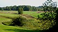
 08120033(Randecker Maar,klein).jpg 640 × 480; 66 KB
-
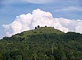
 1dfh georgenberg.jpg 4,000 × 1,704; 1.83 MB
-
 20130316Neues Schloss Stuttgart2.jpg 1,500 × 1,125; 452 KB
-
 Aichelberg (Göppingen) - Turmberg - Waldrand-Silhouette mit untergehender Sonne (1).jpg 7,368 × 5,110; 8.54 MB
-
 Aichelberg.png 448 × 350; 100 KB
-

-
 Blick über das LSG Weilheim an der Teck Richtung Breitenstein und Teck.jpg 2,000 × 1,132; 2.54 MB
-
 Boettinger-Marmor Marmorsaal-Neues-Schloss-Stuttgart.jpg 1,800 × 1,200; 2.27 MB
-
 Burg Teck und Owen.jpg 3,872 × 2,592; 4.01 MB
-
 Böttinger Marmor, Böttingen b Münsingen 01.jpg 4,000 × 2,500; 2.55 MB
-
 Böttinger Marmor, Böttingen b Münsingen 02.jpg 4,000 × 3,000; 3.31 MB
-
 Böttinger Marmor, Böttingen b Münsingen 03.jpg 4,000 × 3,000; 1.96 MB
-
 Böttinger Marmor, Böttingen b Münsingen 04.jpg 4,000 × 3,000; 2.32 MB
-
 DE-BW-ES FND Vulkanembryo Hochbölle LSG Albtrauf Beuren.jpg 2,560 × 1,920; 1.47 MB
-
 DE-BW-ES FND Vulkanembryo Hochbölle.jpg 2,560 × 1,920; 1.36 MB
-
 DE-BW-ES FNDs Vulkanembryo Hochbölle + Spitzberg + Engelberg.jpg 2,560 × 1,920; 1.25 MB
-
 Der Hohenbol.jpg 4,000 × 3,000; 1.38 MB
-
 Die Limburg von Westen über die Streuobstwiesen bei Bissingen an der Teck gesehen (2).jpg 2,000 × 1,328; 3.42 MB
-
 Die Limburg von Westen über die Streuobstwiesen bei Bissingen an der Teck gesehen (3).jpg 2,000 × 1,328; 3.24 MB
-
 Donnstetten.jpg 3,008 × 2,000; 4.1 MB
-
 GeorgenbergAlbtrauf.jpg 1,500 × 843; 166 KB
-
 Hohenbol - Gipfel.JPG 1,006 × 632; 121 KB
-
 Hohenbol und Teckberg.JPG 1,318 × 653; 111 KB
-
 Karst-Quellflur Hirnkopf-Maar Schw-Alb.JPG 1,800 × 1,200; 2.16 MB
-
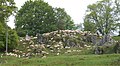
 Konradfels Geotop in Baden Württemberg.jpg 4,000 × 2,672; 3.46 MB
-
 Konradfels Vulkanschlot Schwaebischer-Vulkan Schwaebische-Alb.jpg 1,800 × 1,200; 2.64 MB
-
 Konradfels01.jpg 3,650 × 1,897; 4.73 MB
-
 Lenningen - Naturschutzgebiet Schopflocher Moor, Torfgrube.JPG 4,000 × 2,248; 1.22 MB
-
 Lenninger-Tal Streuobst NSG-Teck Schwaebische-Alb.jpg 1,800 × 1,200; 1.97 MB
-
 Lerchenberg Sternberg Dolinenfeld Schwaebische-Alb.jpg 1,800 × 1,200; 2.63 MB
-
 Limburg aus richtung Neidlingen Hepsisau.jpg 3,000 × 1,787; 1.33 MB
-
 Limburg weilheim teck.jpg 750 × 456; 82 KB
-
 Limburg-Weilheim-2.jpg 3,264 × 2,420; 3.06 MB
-
 ND Geigersbühl Großbettlingen.jpg 4,320 × 3,240; 4.76 MB
-
 Panorama Alb.jpg 4,434 × 1,013; 2.43 MB
-
 Pfullingen-2013-05-14-1dfh.jpg 7,213 × 4,809; 25.66 MB
-
 Randecker Maar.jpg 2,981 × 1,629; 3.54 MB
-
 Randecker-Maar NSG Schwaebische-Alb.jpg 1,806 × 1,200; 1.88 MB
-
 RandeckerMaar-pjt2.jpg 7,891 × 2,996; 5.8 MB
-
 Runder Berg.JPG 1,800 × 1,182; 1.38 MB
-
 Scharnhauser Vulkan, Ostfildern.jpg 2,500 × 1,437; 4.34 MB
-
 Schopflocher Moor, Doline.jpg 3,008 × 2,000; 4.55 MB
-
 Schopflocher Moor.jpg 5,184 × 3,456; 15.23 MB
-
 Schwaebischer-Vulkan aerial Maar-Schlottrichter Zainingen Schwaebische-Alb.jpg 1,800 × 1,200; 2.11 MB
-
 Schwaebischer-Vulkan aerial Schopflocher-Moor Randecker-Maar Limburg.jpg 1,800 × 1,200; 1.94 MB
-
 Schwaebischer-Vulkan Albvorland Scharnhausen-Stuttgart.jpg 1,800 × 1,200; 2.46 MB
-
 Schwaebischer-Vulkan Geo-Relief Urach-Kirchheim.jpg 1,600 × 1,200; 1.42 MB
-
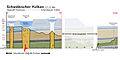 Schwaebischer-Vulkan Geoprofil-Torfmoor-Scharnhauser-Vulkan.jpg 1,600 × 800; 382 KB
-
 Schwaebischer-Vulkan Modellprofil-Jusi.JPG 1,800 × 1,200; 530 KB
-
 Schwaebischer-Vulkan Neuffener-Steige-(Wendenberg) Schwaebische-Alb.jpg 1,800 × 1,200; 2.28 MB
-
 Schwaebischer-Vulkan Scharnhausen-Stuttgart Albvorland.jpg 1,800 × 1,200; 2.76 MB
-
 Schwaebischer-Vulkan Scharnhauser-Vulkan Alb-Vorland.jpg 1,800 × 1,200; 2.69 MB
-
 Schwaebischer-Vulkan-Molach Erkenbrechtsweiler Schwaebische-Alb.JPG 1,600 × 1,200; 2.9 MB
-
 Sternberg Schwaebischer-Vulkan Schwaebische-Alb.jpg 1,800 × 1,200; 1.68 MB
-
 Teck, Naturschutzgebiet im Kreis Esslingen, Baden Württemberg.JPG 2,560 × 1,920; 1.3 MB
-
 Teck, Naturschutzgebiet Kreis Esslingen, Baden-Württemberg.jpg 1,296 × 968; 342 KB
-
 Teckberg.jpg 800 × 600; 119 KB
-
 Weppachtal Owen-Brucken Fruehling Schwaebische Alb.jpg 1,800 × 1,200; 2.42 MB
.jpg)


_-_Turmberg_-_Waldrand-Silhouette_mit_untergehender_Sonne_(1).jpg)


.jpg)
.jpg)


_Schwaebische-Alb.jpg)


