Category:Screen wall, Stanley Park, Liverpool
Jump to navigation
Jump to search
| Object location | | View all coordinates using: OpenStreetMap |
|---|
wall in Liverpool, Merseyside, UK  | |||||
| Upload media | |||||
| Instance of | |||||
|---|---|---|---|---|---|
| Location | Liverpool, Merseyside, North West England, England | ||||
| Heritage designation |
| ||||
 | |||||
This is a category about listed building number 1359842. |
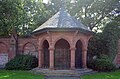
Grade II listed sandstone wall on the south side of Stanley Park, running from the park lodge northeast behind the Isla Gladstone Conservatory, then from the western pavilion to the eastern pavilion parallel to the terrace, and a final section beyond that which runs in a south easterly direction. Along the central section are three shelters.
Media in category "Screen wall, Stanley Park, Liverpool"
The following 12 files are in this category, out of 12 total.
-
 Central shelter, screen wall, Stanley Park.jpg 4,909 × 2,760; 7.27 MB
-
 Eastern shelter, screen wall, Stanley Park.jpg 4,921 × 3,172; 9.51 MB
-
 Isla Gladstone Conservatory from car park.jpg 5,084 × 3,352; 9.96 MB
-
 Screen wall, Stanley Park 1.jpg 5,020 × 3,356; 9.85 MB
-
 Screen wall, Stanley Park 2.jpg 5,141 × 3,268; 13.2 MB
-
 Screen wall, Stanley Park 3.jpg 5,008 × 3,156; 10.46 MB
-
 Screen wall, Stanley Park 4.jpg 5,069 × 3,312; 12.93 MB
-
 Screen wall, Stanley Park 5.jpg 5,283 × 3,522; 15.37 MB
-
 Stanley Park, Liverpool (12).JPG 4,320 × 3,240; 3.76 MB
-
 Stanley Park, Liverpool (13).JPG 4,320 × 3,240; 4.13 MB
-
 Stanley Park, Liverpool (16).JPG 3,240 × 4,320; 3.59 MB
-
 Western shelter, screen wall, Stanley Park.jpg 4,961 × 3,279; 11.41 MB


.JPG)
.JPG)
.JPG)
