Category:Shōō, Okayama
이유: Japanese place names, including municipalities, are officially spelt without macrons; see the Gazetteer of Japan, #3262 provided by the Geospatial Information Authority of Japan
날짜: tagged 2024년 2월 4일.
이의제기나 토론은 Category talk:Shōō, Okayama에서 진행됩니다. (2주 정도가 이의제기가 가능한 적당한 시간으로 여겨집니다.) 일반적인 정보와 정책에 관해서는 Commons:Rename a category를 참조하십시오.
- Category talk:Shōō, Okayama에서 확실한 총의가 모아졌다면 (또는 2주가 지나는 동안 반대가 없었다면), 안내를 지운 후, {{category redirect|Shoo, Okayama}}틀로 바꿔주세요. 도움이 필요하면 Category talk:Requested moves에 요청을 남겨주세요.
- If the proposal is clearly or potentially controversial or requires a broader discussion, you can transfer the discussion to Commons:Categories for discussion (replacing this template with {{subst:cfd}})
- If the proposal is clearly nonsensical, mistaken or consensually rejected, please remove this template.
경고: 처리 시기는 공용 자원 봉사자의 활동에 달려 있습니다. 몇몇 제안(특히 이유가 분명하지 않거나 총의가 없는 경우)은 처리에 여러 달이 소요되기도 합니다.
봇 명령: {{move cat|Shōō, Okayama|Shoo, Okayama|reason=Japanese place names, including municipalities, are officially spelt without macrons; see [https://www.gsi.go.jp/common/000238295.pdf the Gazetteer of Japan, #3262] provided by the Geospatial Information Authority of Japan}}
| − | Category: | + | Category:Shoo, Okayama |
| − | Category:Sh | + | Category:Shoo, Okayama |
town in Katsuta district, Okayama prefecture, Japan    | |||||
| 미디어 올리기 | |||||
| 다음 종류에 속함 | |||||
|---|---|---|---|---|---|
| 위치 |
| ||||
| 법인격 |
| ||||
| 만들어진 날 |
| ||||
| 인구수 |
| ||||
| 면적 |
| ||||
| 다음에서 이어받음 |
| ||||
| 다음으로 이어짐 |
| ||||
| 공식 웹사이트 | |||||
 | |||||

하위 분류
다음은 이 분류에 속하는 하위 분류 5개 가운데 5개입니다.
F
- Former Katsuta County Office (3 F)
K
- Katsumada Station (17 F)
N
- Nishi-Katsumada Station (4 F)
S
- Shoo Service Area (3 F)
U
- Uetsuki Terayama Kofun (5 F)
"Shōō, Okayama" 분류에 속하는 미디어
다음은 이 분류에 속하는 파일 21개 가운데 21개입니다.
-
 Emblem of Shoo, Okayama (black).svg 491 × 393; 1 KB
-
 Emblem of Shoo, Okayama.svg 491 × 393; 1 KB
-
 Flag of Shoo Okayama.png 360 × 237; 12 KB
-
 Flag of Shoo, Okayama.svg 954 × 628; 1 KB
-
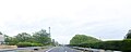 Fukuyoshi Shootown Okayamapref Chugoku Expressway.JPG 1,483 × 589; 403 KB
-
 Japan National Route 179 -03.jpg 2,592 × 1,944; 1.28 MB
-
 Japan National Route 429 -06.jpg 2,592 × 1,944; 1.08 MB
-
 Japan National Route 429 -08.jpg 2,592 × 1,944; 1.24 MB
-
 JRW katsumada sta2.jpg 5,184 × 3,456; 12.5 MB
-
 Kan-on-ji (Sho-o), sanmon.jpg 6,010 × 3,990; 8.62 MB
-
 Map Shouou en,.png 1,281 × 901; 49 KB
-
 Okayama Prefectural Road Route 52 in Shoo -01.jpg 2,560 × 1,920; 2.63 MB
-
 Population distribution of Shouou, Okayama, Japan.svg 512 × 256; 22 KB
-
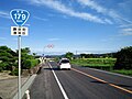 Route179 Shouou.jpg 1,536 × 1,152; 603 KB
-
 Shoo Okayama chapter.JPG 212 × 175; 12 KB
-
 Shoo town office.jpg 1,600 × 1,200; 721 KB
-
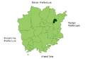
 Shouou in Okayama Prefecture Ja.svg 456 × 536; 10 KB
-
 勝央町勝間田 - panoramio.jpg 1,600 × 900; 191 KB
-
 勝央町小矢田 - panoramio.jpg 1,600 × 900; 228 KB
-
 国道179号線 - panoramio.jpg 1,600 × 900; 205 KB
-
 栗柄神社.jpg 3,935 × 3,022; 5.79 MB
.svg)


,_sanmon.jpg)


