Category:Sir Bobby Robson Bridge
| Object location | | View all coordinates using: OpenStreetMap |
|---|
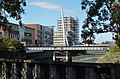
The bridge span is 61m long, 3.7m wide and allows 2.3m of clearance in spring tides. It's supported by a single 35m high wishbone shaped pylon on the west bank, through which passes eight suspension wires in four parallel pairs.
It bridges the River Orwell, although it's often named as being over the River Gipping, as the definition of where the freshwater Gipping becomes the tidal Orwell is vague. Up-river is the Constantine Road wier (which some define as the Gipping/Orwell boundary), while down-river is a rail bridge carrying a goods line. The bridge runs from the corner of Compair Crescent in the Voyage mixed use development on the west bank, to the bend in the West End Road (the A137) in the Ipswich Village area of civic/business buildings on the east side (which is the town side).
It opened in August 2009 and was named after Sir Bobby Robson after a competition in the Evening Star newspaper. Robson was manager of Ipswich Town F.C. from 1969 until 1982, guiding them to success in the 1981 UEFA Cup Final. Ipswich Town's home stadium Portman Road is a short distance away from the east end of the bridge.
It cost around £800,000 and was funded by the property developer Fairview as a condition of obtaining planning permission for the Voyage development, which was built on the site of the former Compair Reavell foundry..jpg) | |||||
| Upload media | |||||
| Instance of | |||||
|---|---|---|---|---|---|
| Location |
| ||||
| Crosses | |||||
 | |||||
Media in category "Sir Bobby Robson Bridge"
The following 27 files are in this category, out of 27 total.
-
 By the Gipping - geograph.org.uk - 1467654.jpg 640 × 424; 106 KB
-

-
 Looking across the new footbridge - geograph.org.uk - 1467739.jpg 640 × 467; 98 KB
-
 New construction along the riverside - geograph.org.uk - 1259851.jpg 640 × 480; 49 KB
-
 New footbridge over the Gipping - geograph.org.uk - 1305119.jpg 640 × 423; 37 KB
-
 New footbridge over the River Gipping - geograph.org.uk - 1467711.jpg 640 × 480; 100 KB
-

-
 Riverside developments, Ipswich - geograph.org.uk - 2833325.jpg 640 × 430; 65 KB
-
 Sir Bobby Robson Bridge - geograph.org.uk - 2833319.jpg 640 × 430; 55 KB
-
 Sir Bobby Robson Bridge - geograph.org.uk - 2833322.jpg 640 × 430; 48 KB
-
 Sir Bobby Robson Bridge - geograph.org.uk - 2833327.jpg 640 × 430; 49 KB
-
 Sir Bobby Robson Bridge - geograph.org.uk - 3855067.jpg 800 × 600; 77 KB
-
 Sir Bobby Robson Bridge - geograph.org.uk - 3855074.jpg 800 × 600; 67 KB
-
 Sir Bobby Robson Bridge - geograph.org.uk - 3995323.jpg 800 × 600; 128 KB
-
 Sir Bobby Robson Bridge, 1 March 2010 (1).jpg 680 × 1,024; 254 KB
-
 Sir Bobby Robson Bridge, 1 March 2010 (10).jpg 1,024 × 576; 192 KB
-
 Sir Bobby Robson Bridge, 1 March 2010 (2).jpg 680 × 1,024; 172 KB
-
 Sir Bobby Robson Bridge, 1 March 2010 (3).jpg 576 × 1,024; 117 KB
-
 Sir Bobby Robson Bridge, 1 March 2010 (4).jpg 680 × 1,024; 124 KB
-
 Sir Bobby Robson Bridge, 1 March 2010 (5).jpg 680 × 1,024; 233 KB
-
 Sir Bobby Robson Bridge, 1 March 2010 (6).jpg 680 × 1,024; 189 KB
-
 Sir Bobby Robson Bridge, 1 March 2010 (7).jpg 680 × 1,024; 277 KB
-
 Sir Bobby Robson Bridge, 1 March 2010 (8).jpg 576 × 1,024; 265 KB
-
 Sir Bobby Robson Bridge, 1 March 2010 (9).jpg 1,024 × 576; 205 KB
-
 Sir Bobby Robson Bridge, Ipswich - geograph.org.uk - 2716518.jpg 2,848 × 2,144; 1.49 MB
-
 Sir Bobby Robson Bridge, Ipswich - geograph.org.uk - 4716645.jpg 3,072 × 2,222; 2.46 MB
-
 Suffolk County Council Offices, Ipswich - geograph.org.uk - 4716661.jpg 3,033 × 2,272; 2.36 MB


.jpg)
.jpg)
.jpg)
.jpg)
.jpg)
.jpg)
.jpg)
.jpg)
.jpg)


