Category:Smooth Island (Tasmania)
Jump to navigation
Jump to search
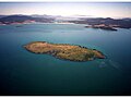
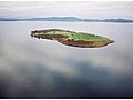
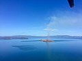
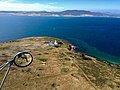
Island close to the south-eastern coast of Tasmania  | |||||
| Upload media | |||||
| Instance of | |||||
|---|---|---|---|---|---|
| Part of |
| ||||
| Location | Tasmania, AUS | ||||
| Located in or next to body of water |
| ||||
| Owned by |
| ||||
| Point in time |
| ||||
| Elevation above sea level |
| ||||
 | |||||
Media in category "Smooth Island (Tasmania)"
The following 44 files are in this category, out of 44 total.
-
 2015-03-31 red sunset.jpg 1,280 × 720; 165 KB
-
 Eastern cove Smooth Island.JPG 3,648 × 2,736; 7.32 MB
-
 Ewqrterwtertewr.jpg 800 × 600; 51 KB
-
 Historic chimney.JPG 1,067 × 800; 170 KB
-
 Island 11 may 2014 -sunset.JPG 1,067 × 800; 104 KB
-
 Island 15june2014.jpg 2,048 × 1,536; 861 KB
-
 Island 15th june2014.JPG 1,067 × 800; 69 KB
-
 Island 15thjune2014.JPG 1,067 × 800; 78 KB
-
 North east.JPG 1,067 × 800; 206 KB
-
 North west.JPG 1,067 × 800; 169 KB
-
 Pebble Beach on Smooth Island Tasmania.JPG 3,648 × 2,736; 6.32 MB
-
 Qerqewrweqr.jpg 800 × 600; 95 KB
-
 SI 2.png 1,107 × 733; 364 KB
-
 Smooth Island (Tasmania) - sunset.jpg 4,000 × 3,000; 5.12 MB
-
 Smooth Island - 1863 survey - full image.png 3,300 × 2,550; 405 KB
-
 Smooth Island - 1863 survey 1.png 1,647 × 2,548; 225 KB
-
 Smooth Island - Edward Pillinger's land title deed.jpg 8,007 × 5,079; 1.38 MB
-
 Smooth Island - Timeline of ownership.png 1,920 × 518; 68 KB
-
 Smooth Island 1.jpg 800 × 600; 49 KB
-
 Smooth Island 2.jpg 800 × 600; 75 KB
-
 Smooth Island 3.JPG 1,024 × 768; 219 KB
-
 Smooth Island 4.JPG 1,024 × 768; 209 KB
-
 Smooth Island 5.JPG 1,024 × 768; 173 KB
-
 Smooth Island 6.JPG 1,024 × 768; 192 KB
-
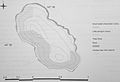
 Smooth Island Contour Map.jpg 521 × 727; 98 KB
-
 Smooth Island fire 2018 -2.jpg 2,048 × 1,536; 264 KB
-
 Smooth Island fire 2018 1.jpg 2,048 × 1,536; 522 KB
-
 Smooth island fish pie chart.png 878 × 674; 109 KB
-
 Smooth Island seabirds.jpg 3,907 × 2,672; 3.64 MB
-
 Smooth Island, geological survey.jpg 738 × 232; 88 KB
-
 Smooth2.JPG 1,067 × 800; 151 KB
-
 Soth west on Smooth Island.JPG 3,648 × 2,736; 6.31 MB
-
 South East cove Smooth Island.JPG 3,648 × 2,736; 6.7 MB
-
 South west view.JPG 1,067 × 800; 212 KB
-
 Sunset on Smooth Island.jpg 1,600 × 1,200; 1.18 MB
-
 Sunset to the west.jpg 1,067 × 800; 113 KB
-
 Sunset view to the west.jpg 1,067 × 800; 120 KB
-
 Top of Smooth island looking at Murdunna.JPG 3,072 × 2,304; 2.4 MB
-
 Tterwtewrtewrt.jpg 800 × 600; 221 KB
-
 Walking track eastern end Smooth Island.jpg 1,600 × 1,200; 271 KB
-
 Walking track southern end Smooth island.jpg 1,600 × 1,200; 667 KB
-
 West coast waves 2.JPG 1,067 × 800; 137 KB
-
 West coast.JPG 1,067 × 800; 214 KB
-
 Yrtytryrty.jpg 800 × 600; 89 KB


_-_sunset.jpg)


