Category:Somfletherwisch Unterfeuer
Jump to navigation
Jump to search
| Object location | | View all coordinates using: OpenStreetMap |
|---|
lighthouse in Lower Saxony, Germany  | |||||
| Upload media | |||||
| Instance of | |||||
|---|---|---|---|---|---|
| Part of | |||||
| Made from material | |||||
| Location | |||||
| Located in or next to body of water | |||||
| Service entry |
| ||||
| Height |
| ||||
| Replaces | |||||
 | |||||
Media in category "Somfletherwisch Unterfeuer"
The following 7 files are in this category, out of 7 total.
-
 Aerial photograph 8358 DxO.jpg 5,184 × 3,456; 3.69 MB
-
 Altes Land IMG 2634 DxO.jpg 1,024 × 682; 96 KB
-
 Elbe (Wedel).Watt.2.ajb.jpg 4,057 × 2,695; 8.4 MB
-
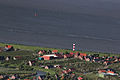
 Luftaufnahmen Nordseekueste 2012-05-by-RaBoe-569.jpg 4,000 × 2,657; 8.47 MB
-
 Luftaufnahmen Nordseekueste 2012-05-by-RaBoe-570.jpg 4,000 × 2,657; 8.86 MB
-
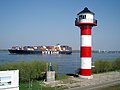 Somfletherwisch New Lighthouse.jpg 3,072 × 2,304; 1.86 MB
-
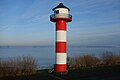 Somfletherwisch range front 1986.jpg 5,472 × 3,648; 2.43 MB


.Watt.2.ajb.jpg)


