Category:South Oxfordshire District
Jump to navigation
Jump to search
local government district in Oxfordshire, England   | |||||
| Upload media | |||||
| Instance of | |||||
|---|---|---|---|---|---|
| Location | Oxfordshire, South East England, England | ||||
| Capital | |||||
| Legislative body |
| ||||
| Inception |
| ||||
| Population |
| ||||
| Area |
| ||||
| official website | |||||
 | |||||
Subcategories
This category has the following 88 subcategories, out of 88 total.
Media in category "South Oxfordshire District"
The following 40 files are in this category, out of 40 total.
-
 20171026 073931 Waterperry .jpg 3,024 × 4,032; 3.28 MB
-
 47 Shooters Hill, Pangbourne EH 1288618 2.jpg 4,032 × 3,024; 1.99 MB
-
 47 Shooters Hill, Pangbourne EH 1288618.jpg 4,032 × 3,024; 2.29 MB
-
 A417, hamlet called Aldworth - panoramio.jpg 4,000 × 3,000; 4.35 MB
-
 Bankside, Pangbourne EH 1130000 2.jpg 4,032 × 3,024; 1.56 MB
-
 Bankside, Pangbourne EH 1130000 3.jpg 4,032 × 3,024; 2.08 MB
-
 Benson Waterfront Riverside Park, Wallingford - panoramio.jpg 2,048 × 1,495; 676 KB
-
 Bridge End Cottage, Clifton Hampden EH 1368815.jpg 3,024 × 4,032; 2.65 MB
-
 Brightwell Barrow - panoramio.jpg 2,343 × 1,429; 938 KB
-
 Camping - panoramio (7).jpg 1,573 × 1,050; 1.1 MB
-
 Castle Hill Wittenham - panoramio.jpg 3,872 × 2,592; 4.27 MB
-
 Check Out These Up And Coming Trends For Engagemen (201755717).jpeg 1,000 × 750; 95 KB
-
 Clematus Cottage Thames View Cottage, Clifton Hampden EH 1368835 2.jpg 4,032 × 3,024; 4.45 MB
-
 Clematus Cottage Thames View Cottage, Clifton Hampden EH 1368835.jpg 4,032 × 3,024; 2.71 MB
-

-
 Clifton Hampden Church of England Primary School and attached teacher's house EH 1059817.jpg 4,032 × 3,024; 1.36 MB
-
 Craigside, Pangbourne EH 1288796 2.jpg 4,032 × 3,024; 2.13 MB
-
 Craigside, Pangbourne EH 1288796.jpg 4,032 × 3,024; 1.97 MB
-
 Fence - panoramio (8).jpg 1,143 × 1,828; 642 KB
-
 Hymn board on the wall - geograph.org.uk - 2108643.jpg 533 × 800; 71 KB
-
 Little Place Cottage, Clifton Hampden EH 1059781.jpg 4,032 × 3,024; 1.98 MB
-
 Lowbury Hill - panoramio (1).jpg 3,872 × 2,592; 3.98 MB
-
 LRM 20190312 173928.jpg 1,650 × 1,920; 1.98 MB
-
 Ordnance Survey Drawings - Reading (OSD 126).jpg 5,679 × 3,450; 4.7 MB
-
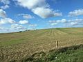
 Road by Coombe Wood - geograph.org.uk - 1233781.jpg 640 × 480; 89 KB
-
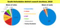 SODC 2015 PieCharts.png 750 × 355; 34 KB
-
 South Oxfordshire population pyramid.svg 2,742 × 2,163; 28 KB
-
 South Oxfordshire UK ward map 2019.svg 526 × 704; 494 KB
-
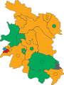 South Oxfordshire UK ward map 2023.svg 526 × 704; 494 KB
-
 South Oxfordshire wards 2019.svg 934 × 1,266; 572 KB
-
 South Stoke, UK - panoramio (1).jpg 3,264 × 2,448; 2.76 MB
-
 South Stoke, UK - panoramio (2).jpg 3,264 × 2,448; 2.65 MB
-
 South Stoke, UK - panoramio (3).jpg 3,264 × 2,448; 2.68 MB
-
 South Stoke, UK - panoramio.jpg 3,264 × 2,448; 1.89 MB
-
 The entrance to HMP Huntercombe (geograph 4182146).jpg 1,500 × 999; 187 KB
-
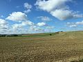
 The River Thame at Brookhampton (geograph 1660990).jpg 1,500 × 1,000; 313 KB
-
 UK SouthOxfordshire DistrictCouncil 2023.svg 360 × 185; 3 KB
-
 Wallingford OX10, UK - panoramio - IIya Kuzhekin.jpg 4,000 × 2,250; 3.05 MB
-
 Wallingford OX10, UK - panoramio.jpg 4,000 × 3,000; 3.3 MB
-
 Wheatfieldchurch.JPG 960 × 1,280; 914 KB


.jpg)

.jpeg)


.jpg)


.jpg)

.jpg)


.jpg)
.jpg)
.jpg)

.jpg)
.jpg)


