Category:Stadtkirche Liebenwalde
Jump to navigation
Jump to search
| Object location | | View all coordinates using: OpenStreetMap |
|---|
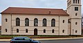
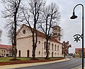
church building in Oberhavel district, Brandenburg state, Germany  .jpg) | |||||
| Upload media | |||||
| Instance of | |||||
|---|---|---|---|---|---|
| Location | Liebenwalde, Oberhavel District, Brandenburg, Germany | ||||
| Heritage designation | |||||
 | |||||
This is the category of the Brandenburger Baudenkmal (cultural heritage monument) with the ID 09165062 (Wikidata)
|
Français : Église de la ville de Liebenwalde, arrondissement de Haute-Havel, état fédéral de Brandebourg, Allemagne
Subcategories
This category has only the following subcategory.
I
Media in category "Stadtkirche Liebenwalde"
The following 11 files are in this category, out of 11 total.
-
 Liebenwalde Kirche.jpg 4,320 × 3,240; 4.45 MB
-
 Liebenwalde, Stadtkirche (01).jpg 4,020 × 3,641; 3.69 MB
-
 Liebenwalde, Stadtkirche (02).jpg 8,000 × 4,187; 4.78 MB
-
 Liebenwalde, Stadtkirche (03).jpg 6,016 × 4,894; 7.09 MB
-
 Liebenwalde, Stadtkirche (04).jpg 7,856 × 3,991; 4.52 MB
-
 Liebenwalde, Stadtkirche (05).jpg 3,900 × 4,552; 4.95 MB
-
 Liebenwalde, Stadtkirche (16).jpg 5,548 × 4,500; 3.44 MB
-
 Liebenwalde, Stadtkirche (17).jpg 1,923 × 4,563; 2.1 MB
-
 Liebenwalde, Stadtkirche (18).jpg 5,692 × 4,532; 5.68 MB
-
 Liebenwalde, Stadtkirche (19).jpg 5,900 × 4,780; 5.61 MB
-
 Stadtkirche Liebenwalde SW 2014.jpg 3,264 × 2,448; 2.91 MB
.jpg)
.jpg)
.jpg)
.jpg)
.jpg)
.jpg)
.jpg)
.jpg)
.jpg)
