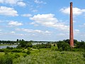
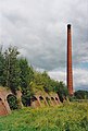
Category:Steenfabriek De Duursche Waarden, Olst
Jump to navigation
Jump to search
| Object location | | View all coordinates using: OpenStreetMap |
|---|
 | |||||
| Upload media | |||||
| Instance of | |||||
|---|---|---|---|---|---|
| Location | Olst, Overijssel, Netherlands | ||||
| Street address |
| ||||
| Heritage designation |
| ||||
| Inception |
| ||||
| Date of official closure |
| ||||
 | |||||
|
This is a category about rijksmonument number 526395
|
| Address |
|
Media in category "Steenfabriek De Duursche Waarden, Olst"
The following 7 files are in this category, out of 7 total.
-
 20150716 Oude Steenfabriek Fortmond.jpg 4,896 × 3,672; 2.08 MB
-
 20150716 Ovenlichaam oude Steenfabriek Fortmond.jpg 4,896 × 3,672; 3.05 MB
-
 20150716 Schoorsteen oude Steenfabriek Fortmond.jpg 4,553 × 3,414; 1.01 MB
-
 FortmondStnfbrk.jpg 1,196 × 1,776; 830 KB
-
 FortmondStnfbrkTrn.jpg 1,196 × 1,780; 946 KB
-
 Molen Mölle van Bats pijp voormalige steenfabriek.jpg 7,148 × 4,755; 3.12 MB
-
 Ringoven bij Fortmond.jpg 1,000 × 667; 795 KB


