Category:Thür
Saltar para a navegação
Saltar para a pesquisa
municipality of Germany    | |||||
| Carregar ficheiro | |||||
| Instância de |
| ||||
|---|---|---|---|---|---|
| Localização | Mendig, Mayen-Koblenz, Renânia-Palatinado, Alemanha | ||||
| População |
| ||||
| Área |
| ||||
| Altitude |
| ||||
| Diferente de | |||||
| sítio web oficial | |||||
 | |||||
Subcategorias
Esta categoria contém as seguintes 3 subcategorias (de um total de 3).
J
N
- Naturschutzgebiet Thürer Wiesen (15 F)
Multimédia na categoria "Thür"
Esta categoria contém os seguintes 8 ficheiros (de um total de 8).
-
 DEU Thür COA.svg 537 × 607; 132 kB
-
 Wappen Thuer.png 301 × 350; 64 kB
-
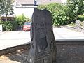
 GedenksteinJudenfriedhof Thür.JPG 2 736 × 3 648; 4,87 MB
-
 Thuerer Somporsch.jpg 2 048 × 1 536; 1,43 MB
-
 Thür in MYK.png 338 × 294; 9 kB
-
 Thür in MYK.svg 660 × 560; 230 kB
-
 Thür.JPG 1 600 × 1 200; 1,27 MB
-
 Thürer Wiesen.jpg 4 272 × 2 848; 972 kB


