Category:Theresienstraße B 189 (Neuburg an der Donau)
Jump to navigation
Jump to search
| Object location | | View all coordinates using: OpenStreetMap |
|---|
building in Neuburg an der Donau, Upper Bavaria, Germany  | |||||
| Upload media | |||||
| Instance of | |||||
|---|---|---|---|---|---|
| Location | Neuburg an der Donau, Neuburg-Schrobenhausen, Upper Bavaria, Bavaria, Germany | ||||
| Street address |
| ||||
| Heritage designation | |||||
 | |||||
This is the category of the Bavarian Baudenkmal (cultural heritage monument) with the ID D-1-85-149-258 (Wikidata)
|
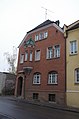
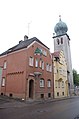
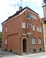
Deutsch: Wohnhaus, sogenanntes Offiziershaus. Zweigeschossiger Eckbau über hohem Kellergeschoss, mit Schopfwalmdach und Erker, um 1906. Bildet mit Theresienstraße B 188 eine einheitliche Baugruppe.
Theresienstraße B 189, Neuburg an der Donau, Bayern, Deutschland
Theresienstraße B 189, Neuburg an der Donau, Bayern, Deutschland
Media in category "Theresienstraße B 189 (Neuburg an der Donau)"
The following 9 files are in this category, out of 9 total.
-
 GER Neuburg an der Donau, Theresienstraße 003.jpg 2,947 × 3,930; 2.62 MB
-
 GER Neuburg an der Donau, Theresienstraße 004.jpg 3,024 × 4,032; 1.91 MB
-
 Theresiensstraße B 189 Neuburg 2016 (01).jpg 3,264 × 4,928; 6.63 MB
-
 Theresiensstraße B 189 Neuburg 2016 (02).jpg 3,264 × 4,928; 7.25 MB
-
 Theresienstr. B188 Neuburg-1.jpg 1,899 × 2,427; 542 KB
-
 Theresienstr. B189 Neuburg-1.jpg 1,944 × 2,442; 694 KB
-
 Theresienstr. B189 Neuburg-2.jpg 1,749 × 2,346; 569 KB
-
 Theresienstr. B189 Neuburg-3.jpg 1,932 × 2,436; 916 KB
-
 Theresienstr. B189-188-187 Neuburg-1.jpg 1,872 × 2,586; 681 KB


.jpg)
.jpg)


