Category:Thrumster, Highland
Jump to navigation
Jump to search
English: Thrumster is a remote crofting township on the main A99 road between Wick and Inverness. It is the nearest village to Wick. The transmission mast used to broadcast BBC television and radio signals to Caithness until 1960.
human settlement in Highland, Scotland, UK  | |||||
| Upload media | |||||
| Instance of | |||||
|---|---|---|---|---|---|
| Location |
| ||||
 | |||||
Media in category "Thrumster, Highland"
The following 15 files are in this category, out of 15 total.
-
 A99 (A9), Thrumster - geograph.org.uk - 2168988.jpg 640 × 480; 78 KB
-
 Deserted farmstead - geograph.org.uk - 487258.jpg 588 × 417; 73 KB
-

-
 House and garage - geograph.org.uk - 487262.jpg 640 × 399; 56 KB
-
 Old Smiddy Inn - geograph.org.uk - 478943.jpg 640 × 480; 120 KB
-
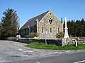 Thrumster Kirk (geograph 5047246).jpg 2,592 × 1,944; 1.78 MB
-
 Thrumster Primary School - geograph.org.uk - 2451066.jpg 1,600 × 1,074; 531 KB
-
 Track to Kinlochy - geograph.org.uk - 543473.jpg 640 × 480; 86 KB
-
 Ulbster WWII Chain Home Low radar station - geograph.org.uk - 14730.jpg 640 × 480; 104 KB
-
 Whiteleen Cottage - geograph.org.uk - 481123.jpg 640 × 469; 58 KB
-
 Examples of Caithness flagstone walling - geograph.org.uk - 487332.jpg 640 × 480; 113 KB
-
 Grudgehouse - geograph.org.uk - 543498.jpg 640 × 480; 112 KB
-
 Heading north to Tanach - geograph.org.uk - 544624.jpg 640 × 480; 75 KB
-
 Looking north at Grudgehouse - geograph.org.uk - 543512.jpg 640 × 480; 83 KB
-
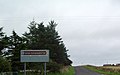 Sign at road junction - geograph.org.uk - 544618.jpg 640 × 402; 54 KB
,_Thrumster_-_geograph.org.uk_-_2168988.jpg)

_from_East_-_geograph.org.uk_-_911639.jpg)


.jpg)


