Category:Torsåkers kyrka, Gästrikland
Jump to navigation
Jump to search
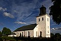
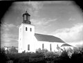
Svenska: Torsåkers kyrka tillhör Torsåkers församling, Gästriklands kontrakt, Uppsala stift / Diocese of Uppsala.
| Object location | | View all coordinates using: OpenStreetMap |
|---|
church building in Hofors Municipality, Sweden  | |||||
| Upload media | |||||
| Instance of | |||||
|---|---|---|---|---|---|
| Location | Hofors Municipality, Gävleborg County, Sweden | ||||
| Diocese | |||||
| Connects with |
| ||||
| Has use |
| ||||
| Occupant | |||||
| Heritage designation |
| ||||
| Different from | |||||
 | |||||
|
This is a category about an ecclesiastical monument in Sweden, number 21300000005037 (sub-number: 21420000041699) in the RAÄ buildings database.
|
Subcategories
This category has the following 3 subcategories, out of 3 total.
G
- Gästriklands runinskrifter 7 (2 F)
- Gästriklands runinskrifter 8 (1 F)
I
Media in category "Torsåkers kyrka, Gästrikland"
The following 59 files are in this category, out of 59 total.
-
 Torsåker 01.jpg 3,072 × 2,304; 2.3 MB
-
 Torsåker kyrka01.JPG 3,872 × 2,592; 2.72 MB
-
 Torsåker kyrka02.JPG 3,806 × 2,437; 2.43 MB
-
 Torsåker kyrka03.JPG 3,872 × 2,592; 2.04 MB
-
 Torsåkers kyrka - KMB - 16000200032055.jpg 799 × 600; 92 KB
-
 Torsåkers kyrka - KMB - 16000200032068.jpg 800 × 592; 77 KB
-
 Torsåkers kyrka - KMB - 16000200032069.jpg 800 × 503; 107 KB
-
 Torsåkers kyrka - KMB - 16000200032070.jpg 800 × 392; 97 KB
-
 Torsåkers kyrka - KMB - 16000200032074.jpg 800 × 488; 75 KB
-
 Torsåkers kyrka - KMB - 16000200032078.jpg 410 × 600; 64 KB
-
 Torsåkers kyrka - KMB - 16000200032079.jpg 784 × 600; 93 KB
-
 Torsåkers kyrka - KMB - 16000200032080.jpg 789 × 600; 77 KB
-
 Torsåkers kyrka - KMB - 16000200032124.jpg 800 × 580; 75 KB
-
 Torsåkers kyrka - KMB - 16000200032125.jpg 432 × 600; 47 KB
-
 Torsåkers kyrka - KMB - 16000200032129.jpg 430 × 600; 49 KB
-
 Torsåkers kyrka - KMB - 16000200032131.jpg 454 × 600; 74 KB
-
 Torsåkers kyrka - KMB - 16000200032133.jpg 458 × 600; 39 KB
-
 Torsåkers kyrka - KMB - 16000200032137.jpg 443 × 600; 55 KB
-
 Torsåkers kyrka - KMB - 16000200032140.jpg 472 × 341; 9 KB
-
 Torsåkers kyrka - KMB - 16000200032145.jpg 417 × 600; 37 KB
-
 Torsåkers kyrka - KMB - 16000200032146.jpg 800 × 582; 66 KB
-
 Torsåkers kyrka - KMB - 16000200032147.jpg 434 × 600; 44 KB
-
 Torsåkers kyrka - KMB - 16000200032148.jpg 451 × 600; 60 KB
-
 Torsåkers kyrka - KMB - 16000200032149.jpg 442 × 600; 51 KB
-
 Torsåkers kyrka - KMB - 16000200032150.jpg 800 × 582; 124 KB
-
 Torsåkers kyrka - KMB - 16000200032151.jpg 800 × 575; 120 KB
-
 Torsåkers kyrka - KMB - 16000200032152.jpg 436 × 600; 51 KB
-
 Torsåkers kyrka - KMB - 16000200032153.jpg 800 × 574; 129 KB
-
 Torsåkers kyrka - KMB - 16000200032154.jpg 800 × 579; 63 KB
-
 Torsåkers kyrka - KMB - 16000200032156.jpg 405 × 600; 49 KB
-
 Torsåkers kyrka - KMB - 16000200032157.jpg 411 × 600; 29 KB
-
 Torsåkers kyrka - KMB - 16000200032158.jpg 432 × 600; 34 KB
-
 Torsåkers kyrka - KMB - 16000200032159.jpg 407 × 600; 35 KB
-
 Torsåkers kyrka - KMB - 16000200032160.jpg 405 × 600; 47 KB
-
 Torsåkers kyrka - KMB - 16000200032161.jpg 448 × 600; 45 KB
-
 Torsåkers kyrka - KMB - 16000200032162.jpg 334 × 600; 37 KB
-
 Torsåkers kyrka - KMB - 16000200032164.jpg 351 × 600; 31 KB
-
 Torsåkers kyrka - KMB - 16000200032165.jpg 517 × 600; 81 KB
-
 Torsåkers kyrka - KMB - 16000200032166.jpg 646 × 600; 100 KB
-
 Torsåkers kyrka - KMB - 16000200032167.jpg 427 × 600; 71 KB
-
 Torsåkers kyrka - KMB - 16000200032176.jpg 427 × 600; 71 KB
-
 Torsåkers kyrka - KMB - 16000200032177.jpg 455 × 600; 72 KB
-
 Torsåkers kyrka - KMB - 16000200032180.jpg 464 × 600; 83 KB
-
 Torsåkers kyrka - KMB - 16000200032182.jpg 430 × 600; 39 KB
-
 Torsåkers kyrka - KMB - 16000200032183.jpg 426 × 600; 58 KB
-
 Torsåkers kyrka - KMB - 16000200032185.jpg 604 × 600; 94 KB
-
 Torsåkers kyrka 01.jpg 3,072 × 2,304; 2.56 MB
-
 Torsåkers kyrka 02.jpg 3,072 × 2,304; 2.65 MB
-
 Torsåkers kyrka 03.jpg 3,072 × 2,304; 2.74 MB
-
 Torsåkers kyrka 04.jpg 3,072 × 2,304; 2.68 MB
-
 Torsåkers kyrka 05.jpg 2,304 × 3,072; 2.66 MB
-
 Torsåkers kyrka 06.jpg 3,072 × 2,304; 2.61 MB
-
 Torsåkers kyrka 07.jpg 3,072 × 2,304; 2.52 MB
-
 Torsåkers kyrka 08.jpg 3,072 × 2,304; 2.46 MB
-
 Torsåkers kyrka 09.jpg 2,304 × 3,072; 4.51 MB
-
 Torsåkers kyrka 10.jpg 3,072 × 2,304; 2.83 MB
-
 Torsåkers kyrka 11.jpg 3,322 × 1,510; 3.94 MB
-
 Torsåkers kyrka, Gästrikland - Märkligare svenska kyrkor - 0012.jpg 3,141 × 2,309; 1.36 MB
-
 Torsåkers kyrka.JPG 3,008 × 2,000; 2.71 MB


