Category:U.S. Route 16A
Jump to navigation
Jump to search
 | number: | (sixteen) |
|---|---|---|
| U.S. Routes: | 1 · 2 · 3 · 4 · 5 · 6 · 7 · 8 · 9 · 10 · 11 · 12 · 13 · 14 · 15 · 16 · 17 · 18 · 19 · 20 · 21 · 22 · 23 · 24 · 25 · 26 · 27 · 29 · 30 · 31 · 33 · 34 · 35 · 36 |
Alternate U.S. Highway in Custer and Pennignton counties in South Dakota, United States   | |||||
| Upload media | |||||
| Instance of | |||||
|---|---|---|---|---|---|
| Named after |
| ||||
| Location |
| ||||
| Transport network | |||||
| Owned by | |||||
| Maintained by | |||||
| Length |
| ||||
| |||||
U.S. Route 16A (US 16A) is a United States highway located in the Black Hills of South Dakota. It is a scenic auxiliary route of US 16. Portions of this road are known as Iron Mountain Road or Peter Norbeck Memorial Byway. The highway leads to Mount Rushmore National Memorial and Custer State Park.
Subcategories
This category has the following 3 subcategories, out of 3 total.
Media in category "U.S. Route 16A"
The following 13 files are in this category, out of 13 total.
-
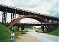 Keystone Wye Bridges.jpg 600 × 428; 78 KB
-
 Mt Rushmore from US16A.jpg 2,367 × 2,182; 1.61 MB
-
 Pigtail bridge and tunnel on US16A.jpg 3,312 × 1,824; 2.04 MB
-
 Pigtail Bridge on US 16A.jpg 3,498 × 1,768; 2.34 MB
-
 SD87 North at US16A Signs.jpg 3,600 × 2,400; 3.21 MB
-
 US 16 East At Keystone Wye.jpg 3,904 × 2,772; 3.04 MB
-
 US 16A map.svg 1,208 × 712; 65 KB
-
 US Route 16A splits from US16.jpg 3,456 × 2,304; 3.04 MB
-
 US16A East with Bump Signs - Keystone SD.jpg 3,600 × 2,400; 3.17 MB
-
 US16A West - Approaching Custer.jpg 3,600 × 2,400; 2.85 MB
-
 US16A West Sign - Large Vehicle Advisory.jpg 3,600 × 2,400; 2.6 MB
-
 US16A West Sign - Near SD87.jpg 3,600 × 2,400; 3.62 MB
-
 US16A West Sign.jpg 3,600 × 2,400; 2.74 MB


