Category:Unidentified feature (Sukhothai) 01
Jump to navigation
Jump to search
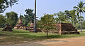
Deutsch: Zentraler Bereich des Geschichtsparks Sukhothai, rund 250 m westlich von Wat Chang Songkhram und nördlich der Insel von Wat Traphang Ngoen
English: Central part of Sukhothai historical park, nearly 250 m west of Wat Chang Songkhram and north of the island of Wat Thraphang Ngoen
| Object location | | View all coordinates using: OpenStreetMap |
|---|
Media in category "Unidentified feature (Sukhothai) 01"
The following 4 files are in this category, out of 4 total.
-
 201312141138a Sukothai, NO NAME 1.jpg 4,516 × 2,496; 9.49 MB
-
 201312141139b Sukothai, NO NAME 1.jpg 4,416 × 2,962; 11.85 MB
-
 201312141140a Sukothai, NO NAME 1.jpg 4,524 × 3,004; 11.82 MB
-
 201312141141b Sukothai, NO NAME 1.jpg 4,608 × 2,784; 10.68 MB


