Category:Urbanization
跳转到导航
跳转到搜索

人口向城鎮聚集和城市範圍不斷擴大,鄉鎮變為城鎮的過程  | |||||
| 上传媒体 | |||||
| 口语音频文件 | |||||
|---|---|---|---|---|---|
| 上级分类 |
| ||||
| 话题方面 | |||||
| |||||
子分类
本分类有以下7个子分类,共有7个子分类。
D
G
L
M
U
分类“Urbanization”中的媒体文件
以下103个文件属于本分类,共103个文件。
-
 2015 World Urbanization Map.png 800 × 317;158 KB
-
 7CHATEAUBLANCVACHE.jpg 600 × 400;78 KB
-
 Agglo19502050.png 4,341 × 2,852;535 KB
-
 AITUnew.jpg 985 × 768;161 KB
-
 Attractivité territoriale (VEOLIA,2009) (4400971679).jpg 1,149 × 706;175 KB
-
 Attractivité territoriale (VEOLIA,2009) (4401736854).jpg 1,125 × 635;122 KB
-
 Attractivité territoriale (VEOLIA,2009) (4401736930).jpg 1,149 × 632;184 KB
-
 Avenida Hercílio Luz e rio da bulha Florianópolis.png 1,318 × 674;401 KB
-
 Avenida Lorena (Jardins Paulista).jpg 3,775 × 3,223;2.59 MB
-
 BelarusUrbanization2009v2.PNG 1,550 × 1,212;73 KB
-
 Blue Banana.png 767 × 534;24 KB
-
 Canggu Shortcut Panorama 2013 vs 2023.jpg 4,032 × 3,170;5.43 MB
-
 Cerrillos - Loma del Aparato - 2020.jpg 5,184 × 3,888;6.98 MB
-
 Colmenar de Oreja 1978.jpg 5,278 × 2,070;6.03 MB
-
 Crisis! Water, Health, Education even Identity.jpg 5,184 × 3,456;4.66 MB
-
 Divide.jpg 3,092 × 4,554;1.2 MB
-
 Ecosistema urbano.png 626 × 419;54 KB
-
En-Urbanization.ogg 8分58秒;5.06 MB
-
 Extent-of-urbanization (OWID 0334).png 850 × 600;90 KB
-
 Global urbanization.png 1,425 × 625;41 KB
-
 Harmony in Habitat.jpg 4,624 × 2,136;999 KB
-
 Hayward fault california.tif 2,135 × 2,386;10.56 MB
-
 Historical global urban - rural population trends.png 1,426 × 1,037;109 KB
-
 Kaloum Peninsula 1986.jpg 2,000 × 1,500;4.21 MB
-
 Kaloum Peninsula 2000.jpg 2,000 × 1,500;4.47 MB
-
 The lure of the past, the present and future (IA lureofpastpresen00brya).pdf 750 × 1,102,174页;9.07 MB
-
 Madrid, Moratalaz 1975 28.jpg 1,048 × 660;755 KB
-
 Madrid, Moratalaz 1975 30.jpg 1,036 × 596;602 KB
-
 Madrid, Moratalaz 1975 31.jpg 704 × 947;653 KB
-
 Madrid, Moratalaz 1975 32.jpg 1,054 × 671;939 KB
-
 Madrid, Moratalaz 1975 33.jpg 1,066 × 698;762 KB
-
 Nature exiled.jpg 4,288 × 2,854;1.97 MB
-

-
 Owner-Occupied Units in Urban Areas.jpg 3,300 × 2,549;2.62 MB
-
 PC 055 428 13 C0002 Degradation du paysage.JPG 3,072 × 2,304;3.05 MB
-
 PC 055 428 13 C0002 Entree de village.JPG 3,072 × 2,304;2.67 MB
-
 PC 055 428 13 C0002 Gaspillage terres agricoles Pilliere.JPG 3,072 × 2,304;2.79 MB
-
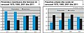
 Percentage of Population Living in urban areas 1950-2050.png 700 × 451;33 KB
-
 Percentage of Population Residing in Urban Areas 1950-2050.png 1,658 × 707;114 KB
-
 Percentage of World Population Urban Rural.PNG 1,118 × 541;15 KB
-
 Petrel 1978 21.jpg 5,370 × 2,095;11.89 MB
-
 Petrel 1978 22.jpg 5,331 × 2,107;8.02 MB
-
 Pop urbane vs po rurale.png 300 × 247;27 KB
-
 Population of Budapest.png 970 × 604;27 KB
-
 Population-threshold-for-urban-area (OWID 0822).png 850 × 600;121 KB
-
 Rezé 1900-1945.png 434 × 411;97 KB
-
 Rezé 1945-1975.png 434 × 411;126 KB
-
 Rezé 1975-2004.png 434 × 411;137 KB
-
 Rezé avant 1900.png 434 × 411;85 KB
-
 Ruseifa. general View 1964.jpg 512 × 371;53 KB
-
 Site de la Cantine, Le Relecq-Kerhuon.jpg 3,264 × 1,472;1.72 MB
-
 Sols perte relativeUE20 EEAEen1.jpg 1,265 × 610;130 KB
-
 Sols perte UE AAE Français modifié-1.jpg 1,265 × 610;135 KB
-
 Sols perte UE20 AAE.jpg 1,265 × 610;116 KB
-
 SolsAgricolesPerte relativeUE20 EEA Fr.jpg 1,265 × 610;124 KB
-
 South Korea urbanization.svg 850 × 950;715 KB
-
 Stedelijk-milieu.jpg 1,023 × 389;73 KB
-
 São Paulo em um dia de maio de 23 2.jpg 4,080 × 3,060;4.62 MB
-
 São Paulo em um dia de maio de 23 3.jpg 4,080 × 2,296;4.25 MB
-
 São Paulo em um dia de maio de 23 4.jpg 4,080 × 3,060;4.31 MB
-
 São Paulo em um dia de maio de 23 5.jpg 4,080 × 3,060;3.7 MB
-
 São Paulo em um dia de maio de 23 6.jpg 4,000 × 3,000;3.22 MB
-
 São Paulo em um dia de maio de 23 7.jpg 4,000 × 3,000;3.15 MB
-
 São Paulo em um dia de maio de 23.jpg 4,000 × 3,000;3.67 MB
-
 São Paulo Vista de um viaduto.jpg 4,080 × 1,551;1.42 MB
-
 TableauCodination des addressesfinal3a.pdf 1,275 × 1,650,26页;851 KB
-
 Tehran Urbanization.gif 2,433 × 2,433;7.86 MB
-
 The African and Asian belts of least urbanized countries.png 1,425 × 966;274 KB
-
 The lure of the past, the present and future (1911) (14596371480).jpg 1,432 × 1,976;307 KB
-
 The lure of the past, the present and future (1911) (14596372140).jpg 1,928 × 2,468;885 KB
-
 The lure of the past, the present and future (1911) (14596409169).jpg 2,004 × 2,476;1 MB
-
 The lure of the past, the present and future (1911) (14596436148).jpg 2,000 × 1,424;409 KB
-
 The lure of the past, the present and future (1911) (14760084826).jpg 2,480 × 1,312;645 KB
-
 The lure of the past, the present and future (1911) (14760086186).jpg 1,940 × 1,280;278 KB
-
 The lure of the past, the present and future (1911) (14779933541).jpg 1,980 × 1,488;378 KB
-
 The lure of the past, the present and future (1911) (14779935161).jpg 2,000 × 1,472;462 KB
-
 The lure of the past, the present and future (1911) (14779936701).jpg 1,952 × 1,424;404 KB
-
 Uden StedelijkeRegio.gif 375 × 204;13 KB
-
 UkraineUrbanization2010.PNG 571 × 434;41 KB
-
 UrbaChina Kick-off.JPG 4,368 × 2,912;5.36 MB
-

-
 Urban and Rural Populations.png 1,542 × 968;149 KB
-
 Urban population in 2005 world map.PNG 1,800 × 820;219 KB
-
 Urban population in 2007 world map.PNG 1,370 × 628;40 KB
-
 Urbanisation dans le monde en 2011.png 1,005 × 602;156 KB
-
 Urbanisation graffito.jpg 1,106 × 646;342 KB
-
 Urbanisation grandes villes.jpg 509 × 289;55 KB
-
 Urbanisation-degree.png 1,425 × 625;55 KB
-
 Urbanisme (28531288536).jpg 4,000 × 4,955;9.47 MB
-
 Urbanización las palmeras - PIURA.jpg 679 × 452;40 KB
-
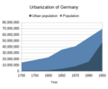 Urbanization of Germany.png 413 × 340;15 KB
-
 Urbanization since 1500.png 1,648 × 1,100;199 KB
-
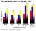 Urbanization-region.jpg 554 × 480;43 KB
-
 Urbanization.PNG 571 × 434;40 KB
-
 Urbanization1897ua.PNG 553 × 446;31 KB
-
 Urbanized population 2006.png 3,600 × 1,640;550 KB
-
 Urbanizmi.jpg 356 × 141;12 KB
-
 Urbansierung.svg 659 × 404;2.41 MB
-
 Urbanworld19502050.svg 659 × 404;2.22 MB
-
 URBE PORTO.JPG 2,240 × 1,488;1.38 MB
-
 World Night Lights Map.jpg 917 × 380;33 KB
-
 Współczynnik urbanizacji w Europie.png 408 × 433;15 KB
-
 Urbanisation of Gleann Sheileach - geograph.org.uk - 353041.jpg 640 × 480;118 KB


_(4400971679).jpg)
_(4401736854).jpg)
_(4401736930).jpg)

.jpg)


.png)


.svg)


.png)


_(14596371480).jpg)
_(14596372140).jpg)
_(14596409169).jpg)
_(14596436148).jpg)
_(14760084826).jpg)
_(14760086186).jpg)
_(14779933541).jpg)
_(14779935161).jpg)
_(14779936701).jpg)


),_OWID.svg)


.jpg)


