Category:Utah Territory
Salti al navigilo
Salti al serĉilo
territory of the United States between 1850 and 1896   .jpg) | |||||
| Alŝuti plurmedion | |||||
| Estas | |||||
|---|---|---|---|---|---|
| Loko | Usono | ||||
| Ĉefurbo | |||||
| Formo de registaro | |||||
| Dato de fondo aŭ kreo |
| ||||
| Dato de malfondo aŭ malkreo |
| ||||
| Anstataŭigas | |||||
| Anstataŭiĝas per | |||||
 | |||||
English: Media related to the Utah Territory, an organized incorporated territory of the United States that existed from September 9, 1850, until January 4, 1896, when the final extent of the territory was admitted to the Union as the State of Utah.
Subkategorioj
Ĉi tiu kategorio havas la 29 jenajn subkategoriojn, el 29 entute.
B
D
- Deseret (proposed state) (22 D)
F
- Fort Supply (Utah Territory) (3 D)
G
M
N
- Nauvoo Legion (11 D)
P
- A Peep at Washoe (1 P, 42 D)
S
- Sugar House Prison (10 D)
U
Dosieroj en kategorio “Utah Territory”
La jenaj 32 dosieroj estas en ĉi tiu kategorio, el 32 entute.
-
 US-UT(1891) p833 (former) State of Deseret.jpg 1 729 × 635; 719 KB
-
 A Very Early Typewritten Letter as Part of a Court Case in the Utah Territory, dated 1886.tif 4 750 × 7 346; 52,31 MB
-
 Alleged Mormon flag 1877.svg 1 000 × 600; 9 KB
-
 Residence of Ben Hampton, Bear River stage station, Utah, by Savage & Ottinger.jpg 2 722 × 1 369; 1,29 MB
-
 Carson Lake from the east, Sierra Nevada in the distance - NARA - 305639.jpg 3 000 × 1 352; 3,18 MB
-
 Chief Sagwitch and Beawoachee Colorized.jpg 987 × 1 657; 116 KB
-
 Court Testimony from Louisa McLaughlin's land title case file, 1871-1874.jpg 4 644 × 7 518; 1,76 MB
-
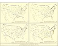 EB9 United States - historical maps (bottom).jpg 2 501 × 2 000; 942 KB
-
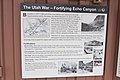 Echo Canyon 0525.jpg 4 608 × 3 072; 3,18 MB
-
 Evolution of borders at Four Corners, USA - June 2013.gif 1 000 × 758; 617 KB
-
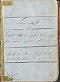
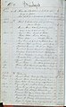 First Salt Lake County Ledger, 1852-1856.jpg 1 198 × 1 925; 196 KB
-
 Flag map of Utah (Mormon Pioneer Flag).png 2 020 × 2 520; 156 KB
-
 Flag of the Utah Territory.svg 682 × 640; 4,06 MB
-
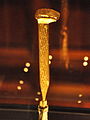 Golden Spike Neil916.JPG 2 665 × 3 557; 4,02 MB
-

-
 Mormon Flag of God´s Kingdom (2002).svg 512 × 307; 27 KB
-

-
 Parley P. Pratt's Land Title Certificate, No. 1048, 1872.jpg 1 632 × 1 224; 144 KB
-
 Probate Court-Land Claim Record, Book 1, Statements 343-349, 1871, pages 116-117.jpg 4 400 × 3 576; 999 KB
-
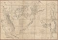
 Reynolds's Political Map of the United States 1856.jpg 7 813 × 7 090; 19,76 MB
-
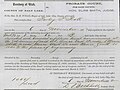
 Salt Lake County Corrected Assessment Roll, Opening Page of Ledger, 1859.jpg 897 × 1 232; 85 KB
-
 SLC (Utah) Council House in 1869.jpg 685 × 515; 110 KB
-
 Territorial Seal of Utah BHoU-p460.png 2 050 × 2 053; 163 KB
-
 Territory and military department of Utah LOC 2015591071.jpg 12 806 × 8 733; 15,9 MB
-
 US-NBN-UT-territory seal detail (Series 1882BB reverse) proof.jpg 1 410 × 1 988; 2,23 MB
-
 Utah territory 1947 U.S. stamp.1.jpg 402 × 269; 168 KB
-
 Utah territory coat of arms (illustrated, 1876).jpg 3 000 × 3 600; 9,08 MB
-
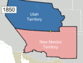
 Utah Territory Evolution - 1868-1896, vector image - 2011.svg 280 × 220; 88 KB
-
 Utah Territory evolution animation - August 2011.gif 1 000 × 786; 158 KB
-
 Washington Monument Deseret Stone in 2000.jpg 2 392 × 1 592; 565 KB
-
 Zion's Bank Promissory Note to pay $1,000 to B.H. Schettler, January 20, 1875.jpg 5 043 × 5 816; 1,24 MB
-
 Residence of Ben Hampton, Bear River stage station, Utah, by Savage & Ottinger.png 2 722 × 1 369; 4,23 MB


.jpg)


.png)


.svg)


_Council_House_in_1869.jpg)


_proof.jpg)


_p833_(former)_State_of_Deseret.jpg)