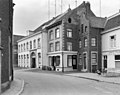
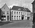
Category:Voorstad Sint Jacob 6, Roermond
Jump to navigation
Jump to search
| Object location | | View all coordinates using: OpenStreetMap |
|---|
building in Roermond, Netherlands  | |||||
| Upload media | |||||
| Instance of | |||||
|---|---|---|---|---|---|
| Part of | |||||
| Location | Roermond, Limburg, Netherlands | ||||
| Street address |
| ||||
| Located on street | |||||
| Heritage designation |
| ||||
 | |||||
|
This is a category about rijksmonument number 32673
|
| Address |
|
Media in category "Voorstad Sint Jacob 6, Roermond"
The following 4 files are in this category, out of 4 total.
-
 Overzicht - Roermond - 20189930 - RCE.jpg 1,200 × 954; 230 KB
-
 RM32673 Roermond.jpg 1,944 × 2,592; 1 MB
-
 Voorgevels - Roermond - 20189932 - RCE.jpg 1,200 × 953; 207 KB
-
 Voorstad Sint Jacob - Roermond - 20189034 - RCE.jpg 1,200 × 1,197; 309 KB


