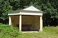
Category:Vredestempeltje, Rijs
Jump to navigation
Jump to search
| Object location | | View all coordinates using: OpenStreetMap |
|---|
 | |||||
| Upload media | |||||
| Instance of | |||||
|---|---|---|---|---|---|
| Location | Rijs, De Fryske Marren, Friesland, Netherlands | ||||
| Street address |
| ||||
| Located on street |
| ||||
| Architectural style | |||||
| Owned by | |||||
| Heritage designation |
| ||||
| Inception |
| ||||
| Date of official opening |
| ||||
 | |||||
|
This is a category about rijksmonument number 15932
|
|
This is a category about a war memorial in the Netherlands, number: 261
|
| Address |
|
Media in category "Vredestempeltje, Rijs"
The following 3 files are in this category, out of 3 total.
-
 20190703 vredestempeltje Rijsterbos.jpg 5,184 × 3,456; 3.99 MB
-
 Rijs - Vredestempel-8.JPG 4,000 × 3,000; 3.63 MB
-
 Vredestempeltje Rijs.jpg 3,750 × 1,368; 796 KB

