Category:Vrijhof 9 (Ferwert)
Jump to navigation
Jump to search
| Object location | | View all coordinates using: OpenStreetMap |
|---|
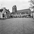
building in Ferwerderadiel, Netherlands  | |||||
| Upload media | |||||
| Instance of | |||||
|---|---|---|---|---|---|
| Location | Ferwert, Noardeast-Fryslân, Friesland, Netherlands | ||||
| Heritage designation |
| ||||
 | |||||
|
This is a category about rijksmonument number 15612
|
|
This is a category about rijksmonument number 15614
|
| Address |
|
Media in category "Vrijhof 9 (Ferwert)"
The following 13 files are in this category, out of 13 total.
-
 20200603 Vrijhof7 8 9 Ferwert.jpg 5,184 × 3,456; 3.41 MB
-
 Achtergevels - Ferwerd - 20073428 - RCE.jpg 1,200 × 955; 250 KB
-
 Achterkant woningkjes bij de kerk Ferwerd (6).JPG 2,592 × 1,944; 809 KB
-
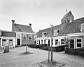
 Boterhoek, achter Vrijhof - Ferwerd - 20073344 - RCE.jpg 1,200 × 809; 238 KB
-
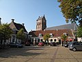 Ferwerd, Vrijthof en kerk 2009-09-19 15.41.JPG 3,456 × 2,592; 1.19 MB
-
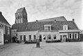 Midden - Ferwerd - 20073426 - RCE.jpg 1,200 × 808; 187 KB
-
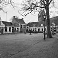 Overzicht - Ferwerd - 20073429 - RCE.jpg 1,195 × 1,200; 348 KB
-
 Overzicht - Ferwerd - 20073430 - RCE.jpg 1,197 × 1,200; 341 KB
-
 Overzicht - Ferwerd - 20073431 - RCE.jpg 1,190 × 1,200; 301 KB
-
 Overzicht met Vrijthof - Ferwerd - 20073334 - RCE.jpg 1,200 × 953; 261 KB
-
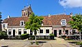
 Overzicht voorgevels - Ferwerd - 20345471 - RCE.jpg 1,200 × 950; 248 KB
-
 Vrijhof7 8 9 Ferwerd.jpg 1,824 × 1,047; 567 KB
-
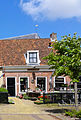 Vrijhof9 Ferwerd.jpg 1,374 × 2,037; 608 KB


.JPG)


