Category:Wiener Straße 14 (Bornheim)
Jump to navigation
Jump to search
| Object location | | View all coordinates using: OpenStreetMap |
|---|
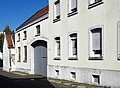
| This category shows a heritage building in Germany, located in the North Rhine-Westphalian city Bornheim (Rheinland) (no. 216). |
Media in category "Wiener Straße 14 (Bornheim)"
The following 3 files are in this category, out of 3 total.
-
 Sechtem Wiener Straße 14 (01).jpg 3,730 × 3,331; 2.59 MB
-
 Sechtem Wiener Straße 14 (02).jpg 2,624 × 4,424; 2.59 MB
-
 Sechtem Wiener Straße 14 (03).jpg 4,893 × 3,605; 3.75 MB
.jpg)
.jpg)
.jpg)