File:Map Thirty Years War-en.svg
Jump to navigation
Jump to search

Size of this PNG preview of this SVG file: 462 × 599 pixels. Other resolutions: 185 × 240 pixels | 370 × 480 pixels | 592 × 768 pixels | 790 × 1,024 pixels | 1,580 × 2,048 pixels | 715 × 927 pixels.
Original file (SVG file, nominally 715 × 927 pixels, file size: 106 KB)
Captions
Captions
Add a one-line explanation of what this file represents
| Description |
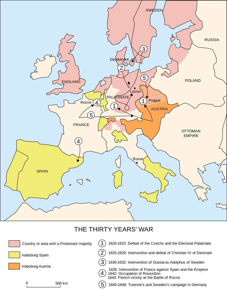
Català: Campanyes de la Guerra dels Trenta Anys |
| Date | (UTC) |
| Source | |
| Author |
|
| Other versions |
File:Map Thirty Years War-en.svg has 2 translations.
|


| This is a retouched picture, which means that it has been digitally altered from its original version. Modifications: English translation. The original can be viewed here: Map Thirty Years War-fr.svg:
|
I, the copyright holder of this work, hereby publish it under the following licenses:
This file is licensed under the Creative Commons Attribution-Share Alike 2.5 Generic, 2.0 Generic and 1.0 Generic license.
- You are free:
- to share – to copy, distribute and transmit the work
- to remix – to adapt the work
- Under the following conditions:
- attribution – You must give appropriate credit, provide a link to the license, and indicate if changes were made. You may do so in any reasonable manner, but not in any way that suggests the licensor endorses you or your use.
- share alike – If you remix, transform, or build upon the material, you must distribute your contributions under the same or compatible license as the original.
| This file is licensed under the Creative Commons Attribution-Share Alike 3.0 Unported license. | ||
| ||
| This licensing tag was added to this file as part of the GFDL licensing update. |

|
Permission is granted to copy, distribute and/or modify this document under the terms of the GNU Free Documentation License, Version 1.2 or any later version published by the Free Software Foundation; with no Invariant Sections, no Front-Cover Texts, and no Back-Cover Texts. A copy of the license is included in the section entitled GNU Free Documentation License. |
You may select the license of your choice.
Original upload log[edit]
This image is a derivative work of the following images:
- File:Map_Thirty_Years_War-fr.svg licensed with Cc-by-sa-2.5,2.0,1.0, Cc-by-sa-3.0-migrated, GFDL
- 2007-06-27T21:25:56Z Bibi Saint-Pol 715x927 (93798 Bytes) {{Information |Description= {{fr|Carte de la Guerre de Trente Ans.}} |Source=Création personnelle. Image renommée depuis [[:Image:La guerre de Trente Ans.svg]] |Date=2006-10-31 |Author=[[User:Historicair|historicair]] |Perm
_en.png)
.png)
.jpg)
Uploaded with derivativeFX
File history
Click on a date/time to view the file as it appeared at that time.
| Date/Time | Thumbnail | Dimensions | User | Comment | |
|---|---|---|---|---|---|
| current | 07:43, 11 October 2023 | | 715 × 927 (106 KB) | Amortres (talk | contribs) | File uploaded using svgtranslate tool (https://svgtranslate.toolforge.org/). Added translation for ca. |
| 17:06, 2 November 2011 |  | 715 × 927 (92 KB) | Johnanth (talk | contribs) | Closer to original, improved translation, fixed typo | |
| 16:03, 18 November 2010 |  | 715 × 927 (93 KB) | P. S. Burton (talk | contribs) | Aligned labels | |
| 15:56, 18 November 2010 |  | 715 × 927 (92 KB) | P. S. Burton (talk | contribs) | {{Information |Description={{fr|Carte de la Guerre de Trente Ans.}}{{en|Map of the Thirty Years' War}} |Source=*File:Map_Thirty_Years_War-fr.svg |Date=2010-11-18 15:55 (UTC) |Author=*[[:File:Map |
You cannot overwrite this file.
File usage on Commons
The following 18 pages use this file:
- Thirty Years War
- User:Magog the Ogre/Maps of conflicts/2023 October
- User:Magog the Ogre/Multilingual legend/2023 October 9-12
- File:Map Thirty Years War-be.svg
- File:Map Thirty Years War-el.png
- File:Map Thirty Years War-en.svg
- File:Map Thirty Years War-fr.svg
- File:Map Thirty Years War-hu.svg
- File:Map Thirty Years War-lb.svg
- File:Map Thirty Years War-rus.svg
- File:Map Thirty Years War-ukr.svg
- File:Map Thirty Years War cs.svg
- File:Τριακονταετής Πόλεμος.svg
- Template:Other versions/Thirty Years War
- Category:Battles of the Thirty Years' War
- Category:Maps of the Thirty Years' War
- Category:People of the Thirty Years' War
- Category:Thirty Years War
File usage on other wikis
The following other wikis use this file:
- Usage on ar.wikipedia.org
- Usage on azb.wikipedia.org
- Usage on ca.wikipedia.org
- Usage on ckb.wikipedia.org
- Usage on el.wikipedia.org
- Usage on en.wikipedia.org
- Usage on en.wikibooks.org
- Usage on et.wikipedia.org
- Usage on ga.wikipedia.org
- Usage on id.wikipedia.org
- Usage on ja.wikipedia.org
- Usage on lv.wikipedia.org
- Usage on nl.wikipedia.org
- Usage on nn.wikipedia.org
- Usage on tr.wikipedia.org
- Usage on www.wikidata.org