File:Troy archeological site (8708437345).jpg

Original file (4,288 × 2,848 pixels, file size: 3 MB, MIME type: image/jpeg)
Captions
Captions
Summary[edit]
| Description |
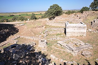
Troy was a city, both factual and legendary, in northwest Anatolia in what is now Turkey, south of the southwest end of the Dardanelles / Hellespont and northwest of Mount Ida. It is best known for being the setting of the Trojan War described in the Greek Epic Cycle and especially in the Iliad, one of the two epic poems attributed to Homer. Metrical evidence from the Iliad and the Odyssey seems to show that the name Ἴλιον (Ilion) formerly began with a digamma: Ϝίλιον (Wilion). This was later supported by the Hittite form Wilusa. A new city called Ilium was founded on the site in the reign of the Roman Emperor Augustus. It flourished until the establishment of Constantinople and declined gradually during the Byzantine era. In 1865, English archaeologist Frank Calvert excavated trial trenches in a field he had bought from a local farmer at Hisarlık, and in 1868, Heinrich Schliemann, wealthy German businessman and archaeologist, also began excavating in the area after a chance meeting with Calvert in Çanakkale. These excavations revealed several cities built in succession. Schliemann was at first skeptical about the identification of Hissarlik with Troy, but was persuaded by Calvert and took over Calvert's excavations on the eastern half of the Hissarlik site, which was on Calvert's property. Troy VII has been identified with the Hittite Wilusa, the probable origin of the Greek Ἴλιον, and is generally (but not conclusively) identified with Homeric Troy. Today, the hill at Hisarlik has given its name to a small village near the ruins, supporting the tourist trade visiting the Troia archaeological site. It lies within the province of Çanakkale, some 30 km south-west of the provincial capital, also called Çanakkale. The nearest village is Tevfikiye. The map here shows the adapted Scamander estuary with Ilium a little way inland across the Homeric plain. Troia was added to the UNESCO World Heritage list in 1998 [Wikipedia.org] |
| Date | |
| Source | Troy archeological site |
| Author | Jorge Láscar from Australia |
| Camera location | | View this and other nearby images on: OpenStreetMap |
|---|
Licensing[edit]
- You are free:
- to share – to copy, distribute and transmit the work
- to remix – to adapt the work
- Under the following conditions:
- attribution – You must give appropriate credit, provide a link to the license, and indicate if changes were made. You may do so in any reasonable manner, but not in any way that suggests the licensor endorses you or your use.
| This image was originally posted to Flickr by Jorge Lascar at https://www.flickr.com/photos/8721758@N06/8708437345. It was reviewed on 2 April 2014 by FlickreviewR and was confirmed to be licensed under the terms of the cc-by-2.0. |

.jpg&action=edit§ion=1)
.jpg¶ms=039.957500_N_0026.238889_E_globe:Earth_type:camera_source:Flickr_&language=en)
.jpg&action=edit§ion=2)
.jpg&action=edit&withJS=MediaWiki:Catcheck.js)
File history
Click on a date/time to view the file as it appeared at that time.
| Date/Time | Thumbnail | Dimensions | User | Comment | |
|---|---|---|---|---|---|
| current | 06:41, 2 April 2014 | | 4,288 × 2,848 (3 MB) | Russavia (talk | contribs) | Transferred from Flickr |
You cannot overwrite this file.
File usage on Commons
There are no pages that use this file.
File usage on other wikis
The following other wikis use this file:
- Usage on it.wikipedia.org
.jpg&oldid=710429964)