File:"TEST STAND NO. 1-3, CONCRETE STRUCTURAL PLAN AND ELEVATION." Specifications No. OC11-50-10; Drawing No. 60-09-06; no sheet number within title block. D.O. SERIES HAER CAL,15-BORON.V,4F-4.tif
Jump to navigation
Jump to search

Size of this JPG preview of this TIF file: 749 × 600 pixels. Other resolutions: 300 × 240 pixels | 599 × 480 pixels | 959 × 768 pixels | 1,279 × 1,024 pixels | 2,557 × 2,048 pixels | 5,200 × 4,165 pixels.
Original file (5,200 × 4,165 pixels, file size: 20.66 MB, MIME type: image/tiff)
Captions
Captions
Add a one-line explanation of what this file represents
Summary[edit]
| Photographer |
Related names:
|
|||
| Title |
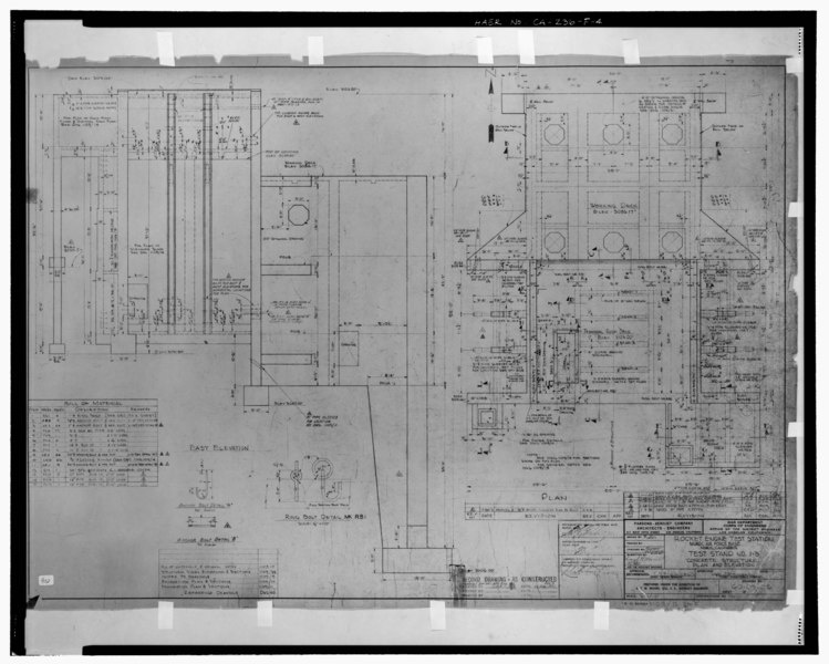
"TEST STAND NO. 1-3, CONCRETE STRUCTURAL PLAN AND ELEVATION." Specifications No. OC11-50-10; Drawing No. 60-09-06; no sheet number within title block. D.O. SERIES 1109-12 REV. E. Stamped- RECORD DRAWING - AS CONSTRUCTED. Below stamp- Contract DA-04-353 Eng. 177, Rev. E; Date- 17 Dec. 1951. - Edwards Air Force Base, Air Force Rocket Propulsion Laboratory, Test Stand 1-3, Test Area 1-115, northwest end of Saturn Boulevard, Boron, Kern County, CA |
|||
| Depicted place | California; Kern County; Boron | |||
| Date | Documentation compiled after 1968 | |||
| Dimensions | 8 x 10 in. | |||
| Current location |
Library of Congress Prints and Photographs Division Washington, D.C. 20540 USA http://hdl.loc.gov/loc.pnp/pp.print |
|||
| Accession number |
HAER CAL,15-BORON.V,4F-4 |
|||
| Credit line |
|
|||
| Notes |
|
|||
| Source | https://www.loc.gov/pictures/item/ca2582.photos.192929p | |||
| Permission (Reusing this file) |
|

| Object location | | View this and other nearby images on: OpenStreetMap |
|---|
File history
Click on a date/time to view the file as it appeared at that time.
| Date/Time | Thumbnail | Dimensions | User | Comment | |
|---|---|---|---|---|---|
| current | 09:25, 7 July 2014 |  | 5,200 × 4,165 (20.66 MB) | Fæ (talk | contribs) | GWToolset: Creating mediafile for Fæ. HABS 05 July 2014 (401:500) |
You cannot overwrite this file.
File usage on Commons
The following page uses this file: