File:Край черники - panoramio.jpg
Jump to navigation
Jump to search

Size of this preview: 800 × 136 pixels. Other resolutions: 320 × 54 pixels | 640 × 109 pixels | 1,024 × 174 pixels | 1,280 × 218 pixels | 7,640 × 1,300 pixels.
Original file (7,640 × 1,300 pixels, file size: 3.14 MB, MIME type: image/jpeg)
Captions
Captions
Add a one-line explanation of what this file represents
Summary
[edit]
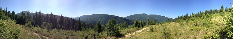
| Description | край черники | ||
| Date | 19 July 2012 (original upload date) | ||
| Source | https://web.archive.org/web/20161024235905/http://www.panoramio.com/photo/75632503 | ||
| Author | Maxim Rozhkov | ||
| Permission (Reusing this file) |
This file is licensed under the Creative Commons Attribution-Share Alike 3.0 Unported license. Attribution: Maxim Rozhkov
|
||
| Tags (from Panoramio photo page) | Tatariv, best |
| Camera location | | View this and other nearby images on: OpenStreetMap |
|---|
File history
Click on a date/time to view the file as it appeared at that time.
| Date/Time | Thumbnail | Dimensions | User | Comment | |
|---|---|---|---|---|---|
| current | 09:17, 8 January 2017 | 7,640 × 1,300 (3.14 MB) | Panoramio upload bot (talk | contribs) | == {{int:filedesc}} == {{Information |description=край черники |date={{Original upload date|2012-07-19}} |source=http://www.panoramio.com/photo/75632503 |author=[http://www.panoramio.com/user/5046756?with_photo_id=75632503 Maxim Rozhkov] |pe... |
You cannot overwrite this file.
File usage on Commons
There are no pages that use this file.