File:1762 Janvier Map of Europe - Geographicus - Europe-janvier-1762.jpg
Jump to navigation
Jump to search
Size of this preview: 800 × 541 pixels. Other resolutions: 320 × 216 pixels | 640 × 432 pixels | 1,024 × 692 pixels | 1,280 × 865 pixels | 2,560 × 1,730 pixels | 3,500 × 2,365 pixels.
Original file (3,500 × 2,365 pixels, file size: 2.81 MB, MIME type: image/jpeg)
Captions
Captions
Add a one-line explanation of what this file represents
Summary[edit]
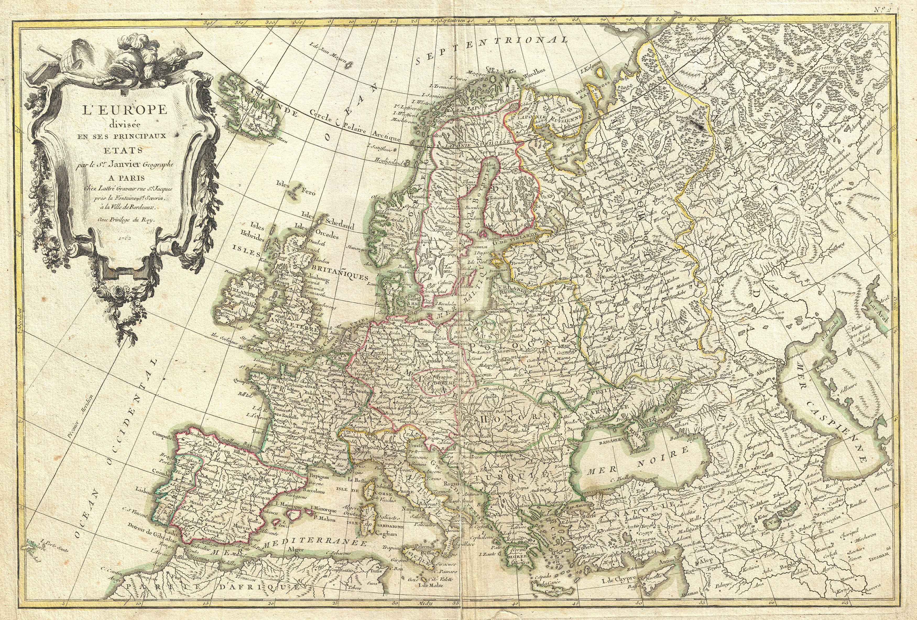
| Jean Janvier: L'Europe divisee en ses Principaux Etats.
( |
|||||||||||||||||
|---|---|---|---|---|---|---|---|---|---|---|---|---|---|---|---|---|---|
| Artist |
|
||||||||||||||||
| Title |
L'Europe divisee en ses Principaux Etats. |
||||||||||||||||
| Description |
English: A beautiful example of Jean Janvier's decorative map of the Europe. Covers from Iceland to the Caspian Sea and from North Africa to the Arctic. Divided into countries and kingdoms with color coding according to region. Offers excellent detail throughout showing mountains, rivers, forests, national boundaries, regional boundaries, forts, and cities. A large decorative title cartouche appears in the upper left quadrant. Drawn by Jean Janvier in 1762 for issue as plate no. 2 in Jean Lattre's 1776 edition of the Atlas Moderne . |
||||||||||||||||
| Date | 1762 (dated) | ||||||||||||||||
| Dimensions | height: 12 in (30.4 cm); width: 18 in (45.7 cm) | ||||||||||||||||
| Accession number |
Geographicus link: Europe-janvier-1762 |
||||||||||||||||
| Source/Photographer |
Lattre, Jean, Atlas Moderne ou Collection de Cartes sur Toutes les Parties du Globe Terrestre, c. 1775.
|
||||||||||||||||
| Permission (Reusing this file) |
|
||||||||||||||||
File history
Click on a date/time to view the file as it appeared at that time.
| Date/Time | Thumbnail | Dimensions | User | Comment | |
|---|---|---|---|---|---|
| current | 18:06, 23 March 2011 | | 3,500 × 2,365 (2.81 MB) | BotMultichillT (talk | contribs) | {{subst:User:Multichill/Geographicus |link=http://www.geographicus.com/P/AntiqueMap/Europe-janvier-1762 |product_name=1762 Janvier Map of Europe |map_title=L'Europe divisee en ses Principaux Etats. |description=A beautiful example of Jean Janvier's decora |
You cannot overwrite this file.
File usage on Commons
The following page uses this file:
File usage on other wikis
The following other wikis use this file:
- Usage on de.wikipedia.org
- Usage on ro.wikipedia.org