File:1847 Levasseur Map of the Dept. de la Haute Garonne, France - Geographicus - Garonne-levasseur-1847.jpg
Jump to navigation
Jump to search

Size of this preview: 404 × 599 pixels. Other resolutions: 162 × 240 pixels | 323 × 480 pixels | 517 × 768 pixels | 690 × 1,024 pixels | 2,022 × 3,000 pixels.
Original file (2,022 × 3,000 pixels, file size: 2.03 MB, MIME type: image/jpeg)
Captions
Captions
Add a one-line explanation of what this file represents
| Dept. De La Haute Garonne | ||||||||||||||||||||||||||||||||||||
|---|---|---|---|---|---|---|---|---|---|---|---|---|---|---|---|---|---|---|---|---|---|---|---|---|---|---|---|---|---|---|---|---|---|---|---|---|
| Artist |
|
|||||||||||||||||||||||||||||||||||
| Title |
Dept. De La Haute Garonne |
|||||||||||||||||||||||||||||||||||
| Description |
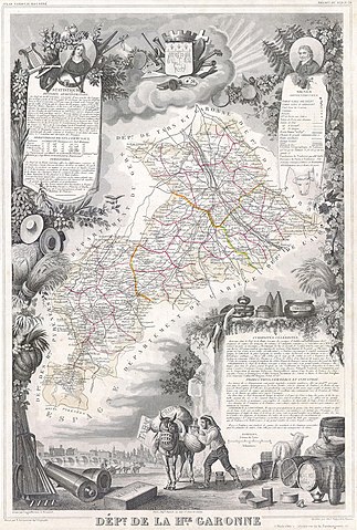
English: This is a fascinating 1847 map of the Department de la Haute Garonne, France. This region is known for its truffles, agriculture, distilled spirits, wines, and cheese. The capital is Toulouse. This region is also an important stop on the medieval pilgrimage route to Santiago de Compostella. The whole is surrounded by elaborate decorative engravings designed to illustrate both the natural beauty and trade richness of the land. There is a short textual history of the regions depicted on both the left and right sides of the map. |
|||||||||||||||||||||||||||||||||||
| Date | 1847 | |||||||||||||||||||||||||||||||||||
| Dimensions | height: 12.5 in (31.7 cm); width: 17.5 in (44.4 cm) | |||||||||||||||||||||||||||||||||||
| Accession number |
Geographicus link: Garonne-levasseur-1847 |
|||||||||||||||||||||||||||||||||||
| Source/Photographer |
|
|||||||||||||||||||||||||||||||||||
| Permission (Reusing this file) |
|
|||||||||||||||||||||||||||||||||||
| Other versions |
|
|||||||||||||||||||||||||||||||||||
_-_Geographicus_-_HautesGaronne-levasseur-1852.jpg)
File history
Click on a date/time to view the file as it appeared at that time.
| Date/Time | Thumbnail | Dimensions | User | Comment | |
|---|---|---|---|---|---|
| current | 08:11, 16 March 2011 | | 2,022 × 3,000 (2.03 MB) | BotMultichill (talk | contribs) | {{subst:User:Multichill/Geographicus |link=http://www.geographicus.com/P/AntiqueMap/Garonne-levasseur-1847 |product_name=1847 Levasseur Map of the Dept. de la Haute Garonne, France |map_title=Dept. De La Haute Garonne |description=This is a fascinating |
You cannot overwrite this file.
File usage on Commons
The following 2 pages use this file:
File usage on other wikis
The following other wikis use this file:
- Usage on fr.wikipedia.org