File:1852 U.S. Coast Survey Map of Cedar Key, Florida - Geographicus - CedarKey-uscs-1852.jpg
Original file (2,500 × 2,189 pixels, file size: 1.16 MB, MIME type: image/jpeg)
Captions
Captions
| G N. 2 U.S. Coast Survey . . . Reconnaissance of Channel No. IV Cedar-Keys Florida. | ||||||
|---|---|---|---|---|---|---|
| Artist | ||||||
| Title |
G N. 2 U.S. Coast Survey . . . Reconnaissance of Channel No. IV Cedar-Keys Florida. |
|||||
| Description |
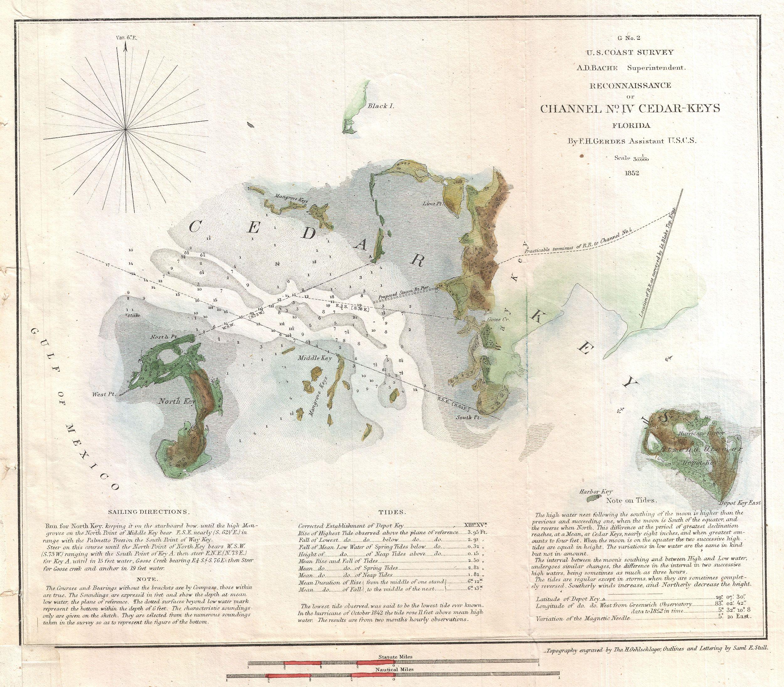
English: This is an important 1852 U.S. Coast Survey mapping of Cedar Key. Following the Seminole Wars, the government pushed for settlement of Florida and increased harvesting of its many natural resources. Cedar Key, situated on the Florida coast between Tampa and Apalachicola, was identified as a central to this plan for its potential as a shipping port. The U.S. Coast survey sent its top Gulf of Mexico expert F. H. Gerdes to survey the Key in anticipation of constructing a Steam Pier and Railroad. Following the Civil War, Cedar Key did in fact develop considerable a shipping trade as well as a number of mills and other factories, but most of these were destroyed in a series of violent hurricanes in the late 19th century. Published in 1852 under the supervision of A.D. Bache, Superintendent of the U.S. Coast Survey. |
|||||
| Date | 1852 (dated) | |||||
| Dimensions | height: 10 in (25.4 cm); width: 11 in (27.9 cm) | |||||
| Accession number |
Geographicus link: CedarKey-uscs-1852 |
|||||
| Source/Photographer |
Report of the Superintendant of the United States Coast Survey, Washington, (1852 edition).
|
|||||
| Permission (Reusing this file) |
|
|||||
File history
Click on a date/time to view the file as it appeared at that time.
| Date/Time | Thumbnail | Dimensions | User | Comment | |
|---|---|---|---|---|---|
| current | 00:04, 24 March 2011 | | 2,500 × 2,189 (1.16 MB) | BotMultichillT (talk | contribs) | {{subst:User:Multichill/Geographicus |link=http://www.geographicus.com/P/AntiqueMap/CedarKey-uscs-1852 |product_name=1852 U.S. Coast Survey Map of Cedar Key, Florida |map_title=G N. 2 U.S. Coast Survey . . . Reconnaissance of Channel No. IV Cedar-Keys Fl |
You cannot overwrite this file.
File usage on Commons
The following page uses this file: