File:1899 Massachusetts railroads map.jpg
Jump to navigation
Jump to search

Size of this preview: 789 × 599 pixels. Other resolutions: 316 × 240 pixels | 632 × 480 pixels | 1,011 × 768 pixels | 1,280 × 972 pixels | 2,560 × 1,945 pixels | 9,384 × 7,128 pixels.
Original file (9,384 × 7,128 pixels, file size: 19.48 MB, MIME type: image/jpeg)
Captions
Captions
Add a one-line explanation of what this file represents
| Warning | The original file is very high-resolution. It might not load properly or could cause your browser to freeze when opened at full size. |
|---|
| Description |
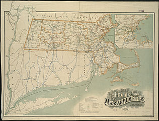
English: 1899 map of railroads in Massachusetts. Boston & Maine lines are in red, Boston & Albany lines in green, New Haven lines in blue, the New London Northern in purple, and the New York Central in black. |
||
| Date | |||
| Source | Norman B. Leventhal Map Center at Boston Public Libraries | ||
| Author | George H. Walker & Co. | ||
| Permission (Reusing this file) |
|
File history
Click on a date/time to view the file as it appeared at that time.
| Date/Time | Thumbnail | Dimensions | User | Comment | |
|---|---|---|---|---|---|
| current | 03:20, 6 June 2013 | | 9,384 × 7,128 (19.48 MB) | Pi.1415926535 (talk | contribs) | {{Information |Description ={{en|1=1899 map of railroads in Massachusetts. Boston & Maine lines are in red, Boston & Albany lines in green, New Haven lines in blue, the New London Northern in purple, and the New York Central in black.}} |Source ... |
You cannot overwrite this file.
File usage on Commons
The following page uses this file:
.jpg&redirect=no)