File:2013 iran pakistan earthquake.jpg
Jump to navigation
Jump to search
Size of this preview: 511 × 600 pixels. Other resolutions: 204 × 240 pixels | 612 × 718 pixels.
Original file (612 × 718 pixels, file size: 124 KB, MIME type: image/jpeg)
Captions
Captions
Add a one-line explanation of what this file represents


| Description |
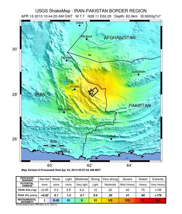
English: M 7.8 Iran - Pakistan Earthquake - Shakemap Français : Carte d'intensité du séisme de 2013 au Sistan-Baloutchistan |
|||
| Date | ||||
| Source | USGS | |||
| Author | USGS | |||
| Permission (Reusing this file) |
|
File history
Click on a date/time to view the file as it appeared at that time.
| Date/Time | Thumbnail | Dimensions | User | Comment | |
|---|---|---|---|---|---|
| current | 21:12, 25 August 2013 | | 612 × 718 (124 KB) | Mikenorton (talk | contribs) | Most recent update of map |
| 08:56, 17 April 2013 |  | 612 × 718 (125 KB) | Tizianok (talk | contribs) | {{Information |Description ={{en|1=M 7.8 Iran - Pakistan Earthquake - Shakemap}} |Source =USGS |Author =USGS |Date =2013-04-17 |Permission ={{PD-USGov-USGS}} |other_versions = }} |
You cannot overwrite this file.
File usage on Commons
There are no pages that use this file.
File usage on other wikis
The following other wikis use this file:
- Usage on da.wikipedia.org
- Usage on en.wikipedia.org
- Usage on fa.wikipedia.org
- Usage on fr.wikipedia.org
- Usage on it.wikipedia.org