File:2cornisland.gif
From Wikimedia Commons, the free media repository
Jump to navigation
Jump to search
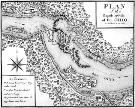
2cornisland.gif (450 × 359 pixels, file size: 90 KB, MIME type: image/gif)
File information
Structured data
Captions
Captions
Add a one-line explanation of what this file represents
Summary[edit]
| Description2cornisland.gif | |
| Date | |
| Source | Victor Collot: A Journey in North America, Containing a survey of the countries watered by the Mississippi, Ohio, Missouri, and other affluing rivers; with exact observations on the course and soundings of these rivers; and on the towns, villages, hamlets and farms of that part of the new-world; followed by philosophical, political, military and commercial remarks and by a projected line of frontiers and genera limits. 2 Vols., Paris, 1826, Plate 17. |
| Author | Victor Collot |
| Other versions | Over the Falls. Discovering Lewis & Clark. |
Licensing[edit]
| Public domainPublic domainfalsefalse |
|
This work is in the public domain in its country of origin and other countries and areas where the copyright term is the author's life plus 100 years or fewer. This work is in the public domain in the United States because it was published (or registered with the U.S. Copyright Office) before January 1, 1929. | |
| This file has been identified as being free of known restrictions under copyright law, including all related and neighboring rights. | |
https://creativecommons.org/publicdomain/mark/1.0/PDMCreative Commons Public Domain Mark 1.0falsefalse
File history
Click on a date/time to view the file as it appeared at that time.
| Date/Time | Thumbnail | Dimensions | User | Comment | |
|---|---|---|---|---|---|
| current | 23:49, 19 April 2006 |  | 450 × 359 (90 KB) | W.marsh (talk | contribs) | Early map of Corn Island and the Falls of the Ohio River in the USA. |
You cannot overwrite this file.
File usage on Commons
There are no pages that use this file.
File usage on other wikis
The following other wikis use this file:
- Usage on de.wikipedia.org
- Usage on en.wikipedia.org
- Usage on fr.wikipedia.org
- Usage on ru.wikipedia.org
