File:5824-5828 - Schynige Platte - View over Brienzersee.jpg
Jump to navigation
Jump to search

Size of this preview: 800 × 140 pixels. Other resolutions: 320 × 56 pixels | 640 × 112 pixels | 1,024 × 179 pixels | 1,280 × 224 pixels | 2,560 × 448 pixels | 15,457 × 2,704 pixels.
Original file (15,457 × 2,704 pixels, file size: 8.59 MB, MIME type: image/jpeg)
Captions
Captions
Add a one-line explanation of what this file represents
| Description |
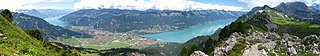
Deutsch: Blick von der Schynige Platte auf den Thunersee, den Brienzersee, Interlaken, Matten, Bönigen, Goldswil, Ringgenberg, Niederried, Oberried, Brienz, Bellenhöchst, Dreispitz, das Morgenberghorn, den Abendberg, das Oberberghorn, das Laucherhorn, das Faulhorn, und das Wetterhorn.
English: Lake Thun, Lake Brienz, Interlaken, Matten, Bönigen, Goldswil, Ringgenberg, Niederried, Oberried, Brienz, Bellenhöchst, Dreispitz, Morgenberghorn, Abendberg, Oberberghorn, Laucherhorn, Faulhorn, and Wetterhorn viewed from Schynige Platte, Switzerland |
| Date | |
| Source |
Own work This panoramic image was created with Autostitch (stitched images may differ from reality). |
| Author | Andrew Bossi |
| Permission (Reusing this file) |
Own work, share alike, attribution required (Creative Commons CC-BY-SA-2.5) |
| Camera location | | View this and other nearby images on: OpenStreetMap |
|---|
I, the copyright holder of this work, hereby publish it under the following license:
This file is licensed under the Creative Commons Attribution-Share Alike 2.5 Generic license.
- You are free:
- to share – to copy, distribute and transmit the work
- to remix – to adapt the work
- Under the following conditions:
- attribution – You must give appropriate credit, provide a link to the license, and indicate if changes were made. You may do so in any reasonable manner, but not in any way that suggests the licensor endorses you or your use.
- share alike – If you remix, transform, or build upon the material, you must distribute your contributions under the same or compatible license as the original.
| Annotations | This image is annotated: View the annotations at Commons |
File history
Click on a date/time to view the file as it appeared at that time.
| Date/Time | Thumbnail | Dimensions | User | Comment | |
|---|---|---|---|---|---|
| current | 00:25, 2 March 2008 | 15,457 × 2,704 (8.59 MB) | Thisisbossi (talk | contribs) | {{Information |Description= {{de|Thunersee, Brienzersee, Interlaken, Matten, Bönigen, Goldswil, Ringgenberg, [[:de:Niederried |
You cannot overwrite this file.
File usage on Commons
The following 2 pages use this file:
File usage on other wikis
The following other wikis use this file:
- Usage on ca.wikipedia.org
- Usage on eo.wikipedia.org
- Brienz BE
- Interlaken
- Grindelwald
- Interlaken (distrikto)
- Ŝablono:Navigilo:Komunumoj de la distrikto Interlaken
- Unterseen
- Habkern
- Beatenberg
- Bönigen
- Matten ĉe Interlaken
- Wilderswil
- Ringgenberg
- Därligen
- Leissigen
- Niederried ĉe Interlaken
- Oberried ĉe la Lago de Brienz
- Brienzwiler
- Gsteigwiler
- Gündlischwand
- Hofstetten ĉe Brienz
- Iseltwald
- Lütschental
- Lauterbrunnen
- Saxeten
- Schwanden ĉe Brienz
- Usage on he.wikipedia.org
Categories:
- Views from Schynige Platte
- Lake Thun
- Lake Brienz
- Breitlauenen
- Bönigen
- Goldswil
- Ringgenberg
- Niederried bei Interlaken
- Oberried am Brienzersee
- Brienzersee at Brienz
- Bellenhöchst
- Dreispitz
- Morgenberghorn
- Därliggrat
- Oberberghorn
- Laucherhorn
- Faulhorn
- Wetterhorn
- Flugplatz Interlaken
- A8 (Switzerland)
- Panoramic views of Interlaken