File:ANGLED VIEW FROM NW Copy photograph of photogrammetric plate LC-HABS-GS05-T-1989-113L. - Glenmont, Llewellyn Park, West Orange, Essex County, NJ HABS NJ,7-ORAW,6-25.tif
Jump to navigation
Jump to search

Size of this JPG preview of this TIF file: 747 × 599 pixels. Other resolutions: 299 × 240 pixels | 598 × 480 pixels | 957 × 768 pixels | 1,276 × 1,024 pixels | 2,552 × 2,048 pixels | 5,000 × 4,012 pixels.
Original file (5,000 × 4,012 pixels, file size: 19.13 MB, MIME type: image/tiff)
Captions
Captions
Add a one-line explanation of what this file represents
Summary[edit]
| ANGLED VIEW FROM NW Copy photograph of photogrammetric plate LC-HABS-GS05-T-1989-113L. - Glenmont, Llewellyn Park, West Orange, Essex County, NJ | ||||
|---|---|---|---|---|
| Photographer |
Borchers, Perry E. |
|||
| Title |
ANGLED VIEW FROM NW Copy photograph of photogrammetric plate LC-HABS-GS05-T-1989-113L. - Glenmont, Llewellyn Park, West Orange, Essex County, NJ |
|||
| Depicted place | New Jersey; Essex County; West Orange | |||
| Date | 1961 | |||
| Dimensions | 8 x 10 in. | |||
| Current location |
Library of Congress Prints and Photographs Division Washington, D.C. 20540 USA http://hdl.loc.gov/loc.pnp/pp.print |
|||
| Accession number |
HABS NJ,7-ORAW,6-25 |
|||
| Credit line |
|
|||
| Notes |
|
|||
| Source | https://www.loc.gov/pictures/item/nj0052.photos.112737p | |||
| Permission (Reusing this file) |
|
|||

| Object location | | View this and other nearby images on: OpenStreetMap |
|---|
File history
Click on a date/time to view the file as it appeared at that time.
| Date/Time | Thumbnail | Dimensions | User | Comment | |
|---|---|---|---|---|---|
| current | 07:44, 29 July 2014 | 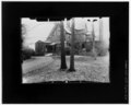 | 5,000 × 4,012 (19.13 MB) | Fæ (talk | contribs) | GWToolset: Creating mediafile for Fæ. HABS 24 July 2014 (2001:2300) |
You cannot overwrite this file.
File usage on Commons
The following page uses this file: