File:APEX OF WEST GABLE, FROM THE ORIGINAL BUILDING PERIOD - Sarum, State Route 234 vicinity, Newport, Charles County, MD HABS MD,9-NEPO.V,1-12.tif
Jump to navigation
Jump to search

Size of this JPG preview of this TIF file: 597 × 600 pixels. Other resolutions: 239 × 240 pixels | 478 × 480 pixels | 765 × 768 pixels | 1,020 × 1,024 pixels | 2,039 × 2,048 pixels | 4,979 × 5,000 pixels.
Original file (4,979 × 5,000 pixels, file size: 23.74 MB, MIME type: image/tiff)
Captions
Captions
Add a one-line explanation of what this file represents
Summary[edit]
| APEX OF WEST GABLE, FROM THE ORIGINAL BUILDING PERIOD - Sarum, State Route 234 vicinity, Newport, Charles County, MD | ||||
|---|---|---|---|---|
| Photographer |
Langenbach, Randolph |
|||
| Title |
APEX OF WEST GABLE, FROM THE ORIGINAL BUILDING PERIOD - Sarum, State Route 234 vicinity, Newport, Charles County, MD |
|||
| Description |
Langenbach, Randolph, photographer |
|||
| Depicted place | Maryland; Charles County; Newport | |||
| Date | Documentation compiled after 1933; 1973 | |||
| Dimensions | 2.25 x 2.25 in. | |||
| Current location |
Library of Congress Prints and Photographs Division Washington, D.C. 20540 USA http://hdl.loc.gov/loc.pnp/pp.print |
|||
| Accession number |
HABS MD,9-NEPO.V,1-12 |
|||
| Credit line |
|
|||
| Notes |
|
|||
| Source | https://www.loc.gov/pictures/item/md0672.photos.087220p | |||
| Permission (Reusing this file) |
|
|||

| Object location | | View this and other nearby images on: OpenStreetMap |
|---|
File history
Click on a date/time to view the file as it appeared at that time.
| Date/Time | Thumbnail | Dimensions | User | Comment | |
|---|---|---|---|---|---|
| current | 05:03, 22 July 2014 | 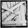 | 4,979 × 5,000 (23.74 MB) | Fæ (talk | contribs) | GWToolset: Creating mediafile for Fæ. HABS 21 July 2014 (1601:1800) |
You cannot overwrite this file.
File usage on Commons
The following page uses this file: