File:Africa temperature-es.png
Jump to navigation
Jump to search

Size of this preview: 444 × 599 pixels. Other resolutions: 178 × 240 pixels | 356 × 480 pixels | 569 × 768 pixels | 759 × 1,024 pixels | 2,036 × 2,747 pixels.
Original file (2,036 × 2,747 pixels, file size: 1.7 MB, MIME type: image/png)
Captions
Captions
Add a one-line explanation of what this file represents
Summary[edit]
| Description |
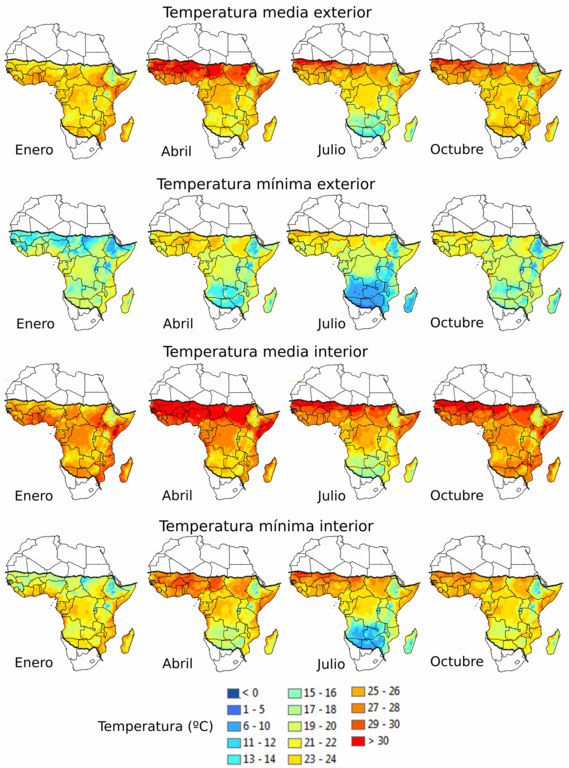
Español: Temperaturas medias y mínimas mensuales al aire libre y en interiores en toda África para enero, abril, julio y octubre.
Temperaturas medias mensuales en exteriores (fila superior) y mínimas (segunda fila). Las superficies de temperatura se generaron por interpolación utilizando los datos de las estaciones meteorológicas recogidos entre 1960 y 1990. Para las zonas en las que los registros de datos eran limitados, como en la República Democrática del Congo, el periodo de tiempo se amplió hasta el año 2000 (véase [45] para más detalles). Los límites geográficos actuales de la transmisión de la malaria están demarcados por las líneas de puntos. Temperaturas medias (tercera fila) y mínimas (fila inferior) mensuales en interiores. Las estimaciones de la temperatura interior se determinaron utilizando ecuaciones de regresión que capturan la relación entre las temperaturas interiores y exteriores a diferentes elevaciones. Estas regresiones se utilizaron para convertir las superficies de temperatura exterior en estimaciones coincidentes de las temperaturas interiores (véase [46] para una información más detallada).
English: Monthly mean and minimum outdoor and indoor temperatures throughout Africa for January, April, July, and October.
Outdoor monthly mean (top row) and minimum (second row) temperatures. Temperature surfaces were generated by interpolation using weather station data collected between 1960 and 1990. For areas where data records were limited, such as in the Democratic Republic of the Congo, the time period was extended to 2000 (see [45] for details). The current geographical limits of malaria transmission are demarcated by the dotted lines. Indoor monthly mean (third row) and minimum (bottom row) temperatures. Indoor temperature estimates were determined using regression equations that capture the relationship between indoor and outdoor temperatures at different elevations. These regressions were used to convert the outdoor temperature surfaces to matching estimates of indoor temperatures (see [46] for more detailed information). |
| Date | |
| Source | Commons File:Africa temperature.png |
| Author |
Katey D. Glunt, Justine I. Blanford, Krijn P. Paaijmans
|
Licensing[edit]
This file is licensed under the Creative Commons Attribution-Share Alike 4.0 International license.
- You are free:
- to share – to copy, distribute and transmit the work
- to remix – to adapt the work
- Under the following conditions:
- attribution – You must give appropriate credit, provide a link to the license, and indicate if changes were made. You may do so in any reasonable manner, but not in any way that suggests the licensor endorses you or your use.
- share alike – If you remix, transform, or build upon the material, you must distribute your contributions under the same or compatible license as the original.
File history
Click on a date/time to view the file as it appeared at that time.
| Date/Time | Thumbnail | Dimensions | User | Comment | |
|---|---|---|---|---|---|
| current | 10:26, 17 June 2021 | | 2,036 × 2,747 (1.7 MB) | NBVC127 (talk | contribs) | Uploaded a work by Katey D. Glunt, Justine I. Blanford, Krijn P. Paaijmans *de la traducción NBVC127 from Commons [https://commons.wikimedia.org/wiki/File:Africa_temperature.png File:Africa temperature.png] with UploadWizard |
You cannot overwrite this file.
File usage on Commons
The following page uses this file:
File usage on other wikis
The following other wikis use this file:
- Usage on es.wikipedia.org