File:All Saints Church - geograph.org.uk - 438119.jpg
All_Saints_Church_-_geograph.org.uk_-_438119.jpg (640 × 359 pixels, file size: 87 KB, MIME type: image/jpeg)
Captions
Captions
Summary[edit]
| Description |
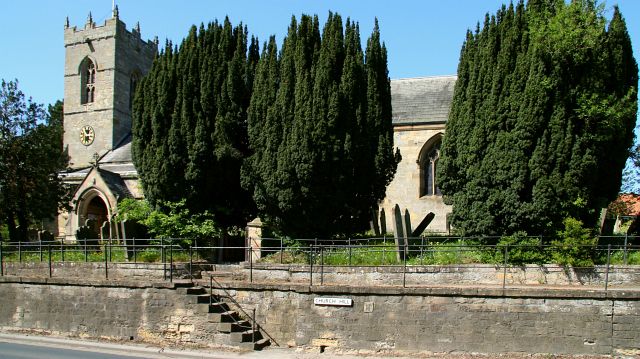
English: All Saints Church This photograph of All Saints Church http://www.freewebs.com/thorntondale/thorntondale.htm was taken from Church Hill / High Street (probably at the junction between the two see below).
The raised pavement is on the northern side of the street and is, perhaps, some 2½metres above the level of the road. The 438747 on the tower has three faces. The 438142 provide access to the churchs 438145 from the road level. According to the OS Map the viewpoint for this photograph is on High Street. However this photograph, taken from the other side of the road, shows the road name as Church Hill. I have made the assumption therefore, that from the viewpoint east is 437969 and from the viewpoint west is 437984. See also this photograph by Chris Allen, 471346 and then this web page from www·ryedale·co·uk http://www.ryedale.co.uk/ryedale/misc/ryedalehistory/grimes.html . |
| Date | |
| Source | From geograph.org.uk |
| Author | Alan Walker |
| Permission (Reusing this file) |
Creative Commons Attribution Share-alike license 2.0 |
| Attribution (required by the license) | Alan Walker / All Saints Church / |
_-_geograph.org.uk_-_437969.jpg)
_-_geograph.org.uk_-_437984.jpg)
| Camera location | | View this and other nearby images on: OpenStreetMap |
|---|
_heading:0.00&language=en)
| Object location | | View this and other nearby images on: OpenStreetMap |
|---|
_heading:0.00&language=en)
Licensing[edit]

|
This image was taken from the Geograph project collection. See this photograph's page on the Geograph website for the photographer's contact details. The copyright on this image is owned by Alan Walker and is licensed for reuse under the Creative Commons Attribution-ShareAlike 2.0 license.
|
- You are free:
- to share – to copy, distribute and transmit the work
- to remix – to adapt the work
- Under the following conditions:
- attribution – You must give appropriate credit, provide a link to the license, and indicate if changes were made. You may do so in any reasonable manner, but not in any way that suggests the licensor endorses you or your use.
- share alike – If you remix, transform, or build upon the material, you must distribute your contributions under the same or compatible license as the original.
File history
Click on a date/time to view the file as it appeared at that time.
| Date/Time | Thumbnail | Dimensions | User | Comment | |
|---|---|---|---|---|---|
| current | 07:01, 4 February 2011 | | 640 × 359 (87 KB) | GeographBot (talk | contribs) | == {{int:filedesc}} == {{Information |description={{en|1=All Saints Church This photograph of All Saints Church http://www.freewebs.com/thorntondale/thorntondale.htm was taken from Church Hill / High Street (probably at the junction between the two see |
You cannot overwrite this file.
File usage on Commons
There are no pages that use this file.