File:Alsace Lorraine departments evolution map-fr.svg
Jump to navigation
Jump to search

Size of this PNG preview of this SVG file: 600 × 450 pixels. Other resolutions: 320 × 240 pixels | 640 × 480 pixels | 1,024 × 768 pixels | 1,280 × 960 pixels | 2,560 × 1,920 pixels.
Original file (SVG file, nominally 600 × 450 pixels, file size: 98 KB)
Captions
Captions
Add a one-line explanation of what this file represents
Summary[edit]
| Description |
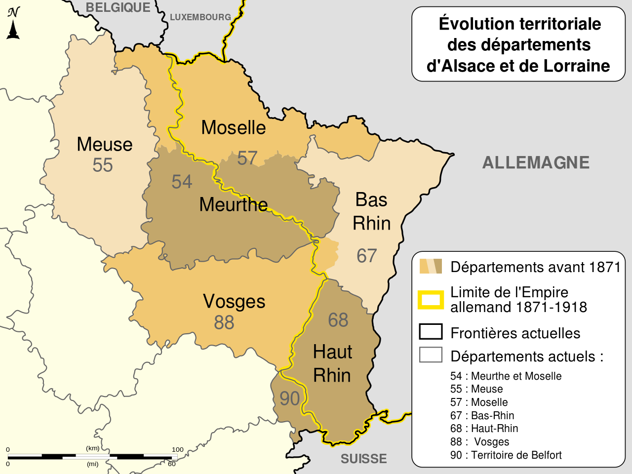
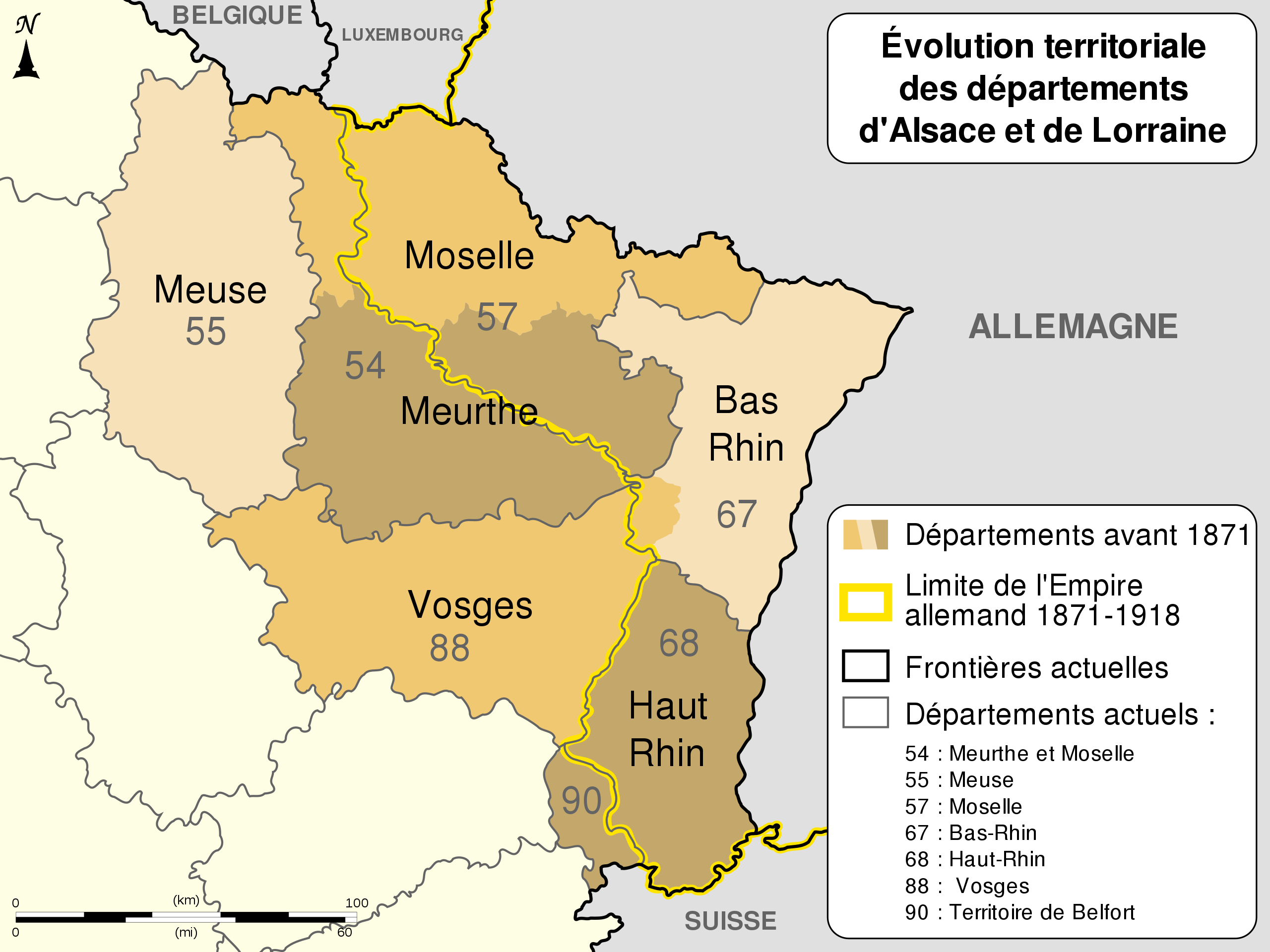
English: Changes of the boundaries of departments in Alsace and Lorraine before and after the German Empire's rule (1871-1918). Français : Évolution territoriale des départements de l'Alsace et de la Lorraine avant et après l'Empire allemand (1871-1918). |
||
| Date | (UTC) | ||
| Source |
Own work. Source :
|
||
| Author | Sémhur (talk) | ||
| Other versions |
[]
Derivative works of this file: | ||
| Attribution (required by the license) | © Sémhur / Wikimedia Commons / | ||
| SVG | W3C-validity not checked.
|
||
| Graphic Lab |


.svg)
| Camera location | | View this and other nearby images on: OpenStreetMap |
|---|
Licensing[edit]
I, the copyright holder of this work, hereby publish it under the following licenses:
| Copyleft: This work of art is free; you can redistribute it and/or modify it according to terms of the Free Art License. You will find a specimen of this license on the Copyleft Attitude site as well as on other sites. |
This file is licensed under the Creative Commons Attribution-Share Alike 4.0 International, 3.0 Unported, 2.5 Generic, 2.0 Generic and 1.0 Generic license.
- You are free:
- to share – to copy, distribute and transmit the work
- to remix – to adapt the work
- Under the following conditions:
- attribution – You must give appropriate credit, provide a link to the license, and indicate if changes were made. You may do so in any reasonable manner, but not in any way that suggests the licensor endorses you or your use.
- share alike – If you remix, transform, or build upon the material, you must distribute your contributions under the same or compatible license as the original.
You may select the license of your choice.
File history
Click on a date/time to view the file as it appeared at that time.
| Date/Time | Thumbnail | Dimensions | User | Comment | |
|---|---|---|---|---|---|
| current | 03:11, 14 July 2013 | | 600 × 450 (98 KB) | Citypeek (talk | contribs) | Corrected two mistakes. Valid SVG now. |
| 08:17, 27 December 2010 |  | 600 × 450 (98 KB) | Sémhur (talk | contribs) | Mistake (Moselle) : 56 => 57 | |
| 17:48, 23 December 2010 |  | 600 × 450 (98 KB) | Sémhur (talk | contribs) | == {{int:filedesc}} == {{Information |Description={{Multilingual description |en= Boundaries evolution of Alsace and Lorraine's departments before and after German Empire (1871-1918). |fr= Évolution territori |
You cannot overwrite this file.
File usage on Commons
The following 11 pages use this file:
- User:M0tty/WWI
- User talk:Floflo
- File:Alsace Lorraine 1.svg
- File:Alsace Lorraine departments evolution map-cs.svg
- File:Alsace Lorraine departments evolution map-de.svg
- File:Alsace Lorraine departments evolution map-en.svg
- File:Alsace Lorraine departments evolution map-es.svg
- File:Alsace Lorraine departments evolution map-fr.svg
- File:Alsace Lorraine departments evolution map-hu.svg
- File:Alsace Lorraine departments evolution map-lb.svg
- Template:Other versions/Alsace Lorraine departments evolution map
File usage on other wikis
The following other wikis use this file:
- Usage on br.wikipedia.org
- Usage on ca.wikipedia.org
- Usage on cs.wikipedia.org
- Usage on de.wikipedia.org
- Usage on el.wikipedia.org
- Usage on eo.wikipedia.org
- Usage on fr.wikipedia.org
- Bas-Rhin
- Département français
- Haut-Rhin
- Lorraine
- Meurthe-et-Moselle
- Moselle (département)
- Territoire de Belfort
- Meurthe (département)
- Histoire de la Lorraine
- Alsace-Lorraine
- Droit local en Alsace et en Moselle
- Alsace-Moselle
- Histoire des départements français
- Grandfontaine (Bas-Rhin)
- Bidépartementalisation
- Portail:Lorraine/Photographie-05
- Portail:Lorraine/Photographie-0510
- Site des trois bornes
- Politique dans la Moselle
- Wikipédia:Atelier graphique/Cartes/Archives/décembre 2010
- Wikipédia:Atelier graphique/Cartes/Archives/novembre 2011
- Discussion:Deuxième République (France)/Article de qualité
- Histoire de la Moselle
- Wikipédia:Atelier graphique/Cartes/Archives/janvier 2015
- 1871 en Lorraine
- Wikipédia:Le Bistro/29 avril 2017
- Histoire de Meurthe-et-Moselle
- Usage on fr.wiktionary.org
- Usage on it.wikipedia.org
- Usage on ja.wikipedia.org
- Usage on zh.wikipedia.org