File:Ammunition Bunkers, Hawthorne Army Depot, Hawthorne, Nevada (15702579465).jpg
Original file (4,000 × 3,000 pixels, file size: 3.45 MB, MIME type: image/jpeg)
Captions
Captions
Summary[edit]
.jpg&action=edit§ion=1)
| Description |
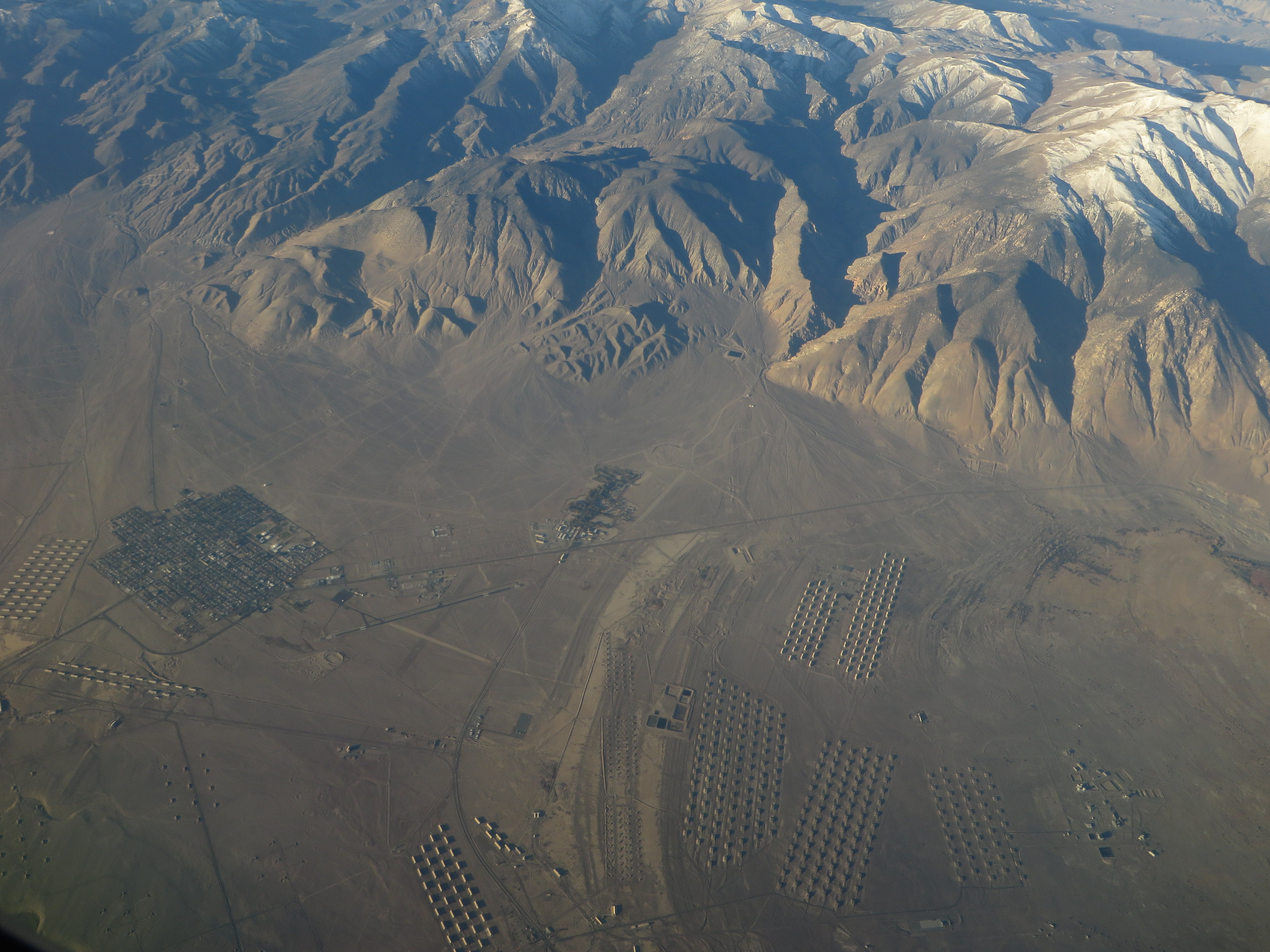
Hawthorne Army Depot (HWAD) is a U.S. Army ammunition storage depot located near the town of Hawthorne in western Nevada in the United States. It is directly south of Walker Lake. The depot covers 147,000 acres (59,000 ha) or 226 sq. mi. and has 600,000 square feet (56,000 m2) storage space in 2,427 bunkers. HWAD claims to be the "Worlds Largest Depot" and is divided into three ammunition storage and production areas, plus an industrial area housing command headquarters, facilities engineering shops, etc. Hawthorne Army Depot stores reserve ammunitions to be used after the first 30 days of a major conflict. As such, it is only partially staffed during peacetime, but provision has been made to rapidly expand staffing as necessary. The depot is run by an independent contractor under an agreement with the government. Capabilities of the center include: demilitarization, desert training for military units, ammunition renovation, quality assurance, ISO intermodal container maintenance/repair, and range scrap processing. The Naval Ammunition Depot Hawthorne was established in September 1930. It was redesignated Hawthorne Army Ammunition Plant in 1977 when it transferred to Army control as part of the Single Manager for Conventional Ammunition. In 1994, it ended its production mission and became Hawthorne Army Depot. Security for the 3,000 bunkers at NAD was provided by the U.S. Marine Corps. Beginning in September 1930 and during World War II, 600 Marines were assigned to the facility. In 1977, that number had been reduced to 117; security is now contracted to a private company. The mission and functions at NAD remained much the same over the facility's history. The mission, as stated in a 1962 Navy Command History, was to "receive, renovate, maintain, store and issue ammunition, explosives, expendable ordnance items and/or weapons and technical ordnance material and perform addition tasks as directed by the Bureau of Naval Weapons. It also served as an important ammunition center during the Korean and Vietnam Wars with several thousand structures on 236 square miles (610 km2) of land. Stored ammunition that had been examined and repacked was given the code HAW followed by the last two digits of the year (e.g., HAW 50). In 1977, NAD was transferred to the Army, and renamed the Hawthorne Army Ammunition Plant (HWAAP). In 1980, HWAAP was redesignated as a government-owned contractor-operated facility. Day & Zimmermann Hawthorne Corporation (DZHC) is the current operating contractor. In 1994, the facility received its current name of the Hawthorne Army Depot (HWAD). In 1998-1999, the facility was used to destroy the U.S. stockpile of M687 chemical artillery shells and separate from them their 505 tons (458 metric tons) of binary precursor chemicals. In May 2005, the facility was included on the 2005 Base Realignment and Closure list, with closure being recommended. However, the depot was subsequently dropped from the BRAC list, primarily due to the base's training capability in support of pre-deployment training for OEF-bound Marine Corps units (by MWTC), Navy, and Army SOF. Currently, Reserve Marines from 4th Marine Logistics Group (4th MLG) conduct annual training exercises at the Hawthorne Army Depot as well as surrounding desert areas. Hawthorne Army Depot surrounds the small town of Hawthorne, Nevada, where most of its employees reside. Prior to the facility becoming contractor-operated, it was staffed primarily by civil service workers and military personnel, who were housed on government owned property neighboring Hawthorne, including the now-extinct town of Babbitt and military housing known as Schweer Drive. The housing in Babbitt was made up of large buildings created to be duplexes. The system of trusses allowed all interior walls to be removed without compromising their structure. Since the disposal of Babbitt many of these "Babbitt Houses" have found their way throughout rural Nevada filling a number of uses. During the peak of operations in World War II, additional housing was provided in a former Civilian Conservation Corps camp christened "Camp Jumbo", and in a large adjoining construction camp. The local Sixth Street School (whose building is listed on the National Register of Historic Places) was expanded to serve the population growth. en.wikipedia.org/wiki/Hawthorne_Army_Depot en.wikipedia.org/wiki/Wikipedia:Text_of_Creative_Commons_... |
| Date | |
| Source | Ammunition Bunkers, Hawthorne Army Depot, Hawthorne, Nevada |
| Author | Ken Lund from Reno, Nevada, USA |
| Camera location | | View this and other nearby images on: OpenStreetMap |
|---|
.jpg¶ms=038.547581_N_-118.650914_E_globe:Earth_type:camera_source:Flickr_&language=en)
Licensing[edit]
.jpg&action=edit§ion=2)
- You are free:
- to share – to copy, distribute and transmit the work
- to remix – to adapt the work
- Under the following conditions:
- attribution – You must give appropriate credit, provide a link to the license, and indicate if changes were made. You may do so in any reasonable manner, but not in any way that suggests the licensor endorses you or your use.
- share alike – If you remix, transform, or build upon the material, you must distribute your contributions under the same or compatible license as the original.
| This image was originally posted to Flickr by Ken Lund at https://flickr.com/photos/75683070@N00/15702579465. It was reviewed on 4 December 2015 by FlickreviewR and was confirmed to be licensed under the terms of the cc-by-sa-2.0. |
File history
Click on a date/time to view the file as it appeared at that time.
| Date/Time | Thumbnail | Dimensions | User | Comment | |
|---|---|---|---|---|---|
| current | 04:15, 4 December 2015 | | 4,000 × 3,000 (3.45 MB) | INeverCry (talk | contribs) | Transferred from Flickr via Flickr2Commons |
You cannot overwrite this file.
File usage on Commons
There are no pages that use this file.
.jpg&oldid=790735896)