File:Antarctic Peninsula.jpg
Jump to navigation
Jump to search
Size of this preview: 800 × 591 pixels. Other resolutions: 320 × 236 pixels | 640 × 473 pixels | 1,024 × 757 pixels | 1,280 × 946 pixels | 2,496 × 1,844 pixels.
Original file (2,496 × 1,844 pixels, file size: 3.44 MB, MIME type: image/jpeg)
Captions
Captions
Add a one-line explanation of what this file represents
Summary[edit]
| Description |
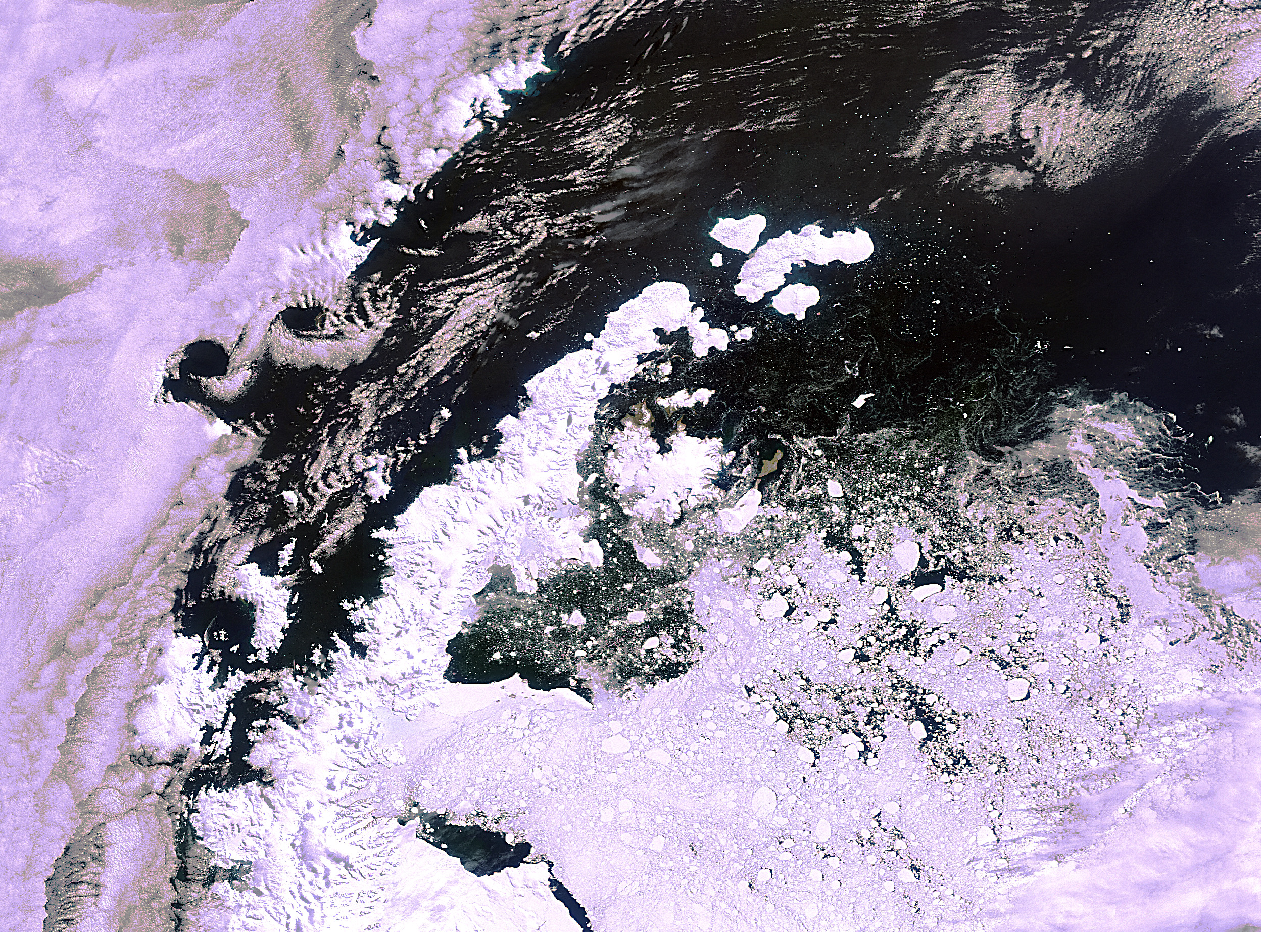
English: This Envisat image features the northern part of the Antarctic Peninsula, which stretches beyond the Antarctic Circle to within 1050 km to the southern tip of South America. The 1000-km-long arm of the mountainous peninsula is situated between the Bellingshausen Sea on the west and the Weddell Sea on the east. Along the peninsula, ice shelves are nourished by glaciers streaming down from the central ice sheet plateau, which extends as a narrow spine along the central part of the peninsula.
This image was acquired by Envisat’s Medium Resolution Imaging Spectrometer (MERIS) on 5 February 2011 at a resolution of 300 m. |
| Date | |
| Source | http://www.esa.int/spaceinimages/Images/2011/02/Antarctic_Peninsula |
| Author | European Space Agency |
| Permission (Reusing this file) |
ESA,CC BY-SA 3.0 IGO |
| Other versions |
|
| Title | Antarctic Peninsula |
| Keywords | Ice and snow; Ice and snow; Ice sheets; Glaciers |
| Set | Earth observation image of the week |
| Mission | Envisat |
| Activity | Observing the Earth |

Licensing[edit]
This file is licensed under the Creative Commons Attribution-ShareAlike 3.0 IGO license.
Attribution: ESA
- You are free:
- to share – to copy, distribute and transmit the work
- to remix – to adapt the work
- Under the following conditions:
- attribution – You must give appropriate credit, provide a link to the license, and indicate if changes were made. You may do so in any reasonable manner, but not in any way that suggests the licensor endorses you or your use.
- share alike – If you remix, transform, or build upon the material, you must distribute your contributions under the same or compatible license as the original.
File history
Click on a date/time to view the file as it appeared at that time.
| Date/Time | Thumbnail | Dimensions | User | Comment | |
|---|---|---|---|---|---|
| current | 02:35, 25 February 2017 | | 2,496 × 1,844 (3.44 MB) | Revent (talk | contribs) | =={{int:filedesc}}== {{Photograph |photographer = Envisat satellite |title = Antarctic Peninsula |description = {{en|This Envisat image features the northern part of the Antarctic Peninsula, which stretches beyond the Antar... |
You cannot overwrite this file.
File usage on Commons
The following 4 pages use this file:
File usage on other wikis
The following other wikis use this file:
- Usage on min.wiktionary.org