File:Anthorn Transmitting Station Communications Masts - Cable Detail ^3 - geograph.org.uk - 1804403.jpg
From Wikimedia Commons, the free media repository
Jump to navigation
Jump to search

Size of this preview: 450 × 600 pixels. Other resolutions: 180 × 240 pixels | 480 × 640 pixels.
Original file (480 × 640 pixels, file size: 55 KB, MIME type: image/jpeg)
File information
Structured data
Captions
Captions
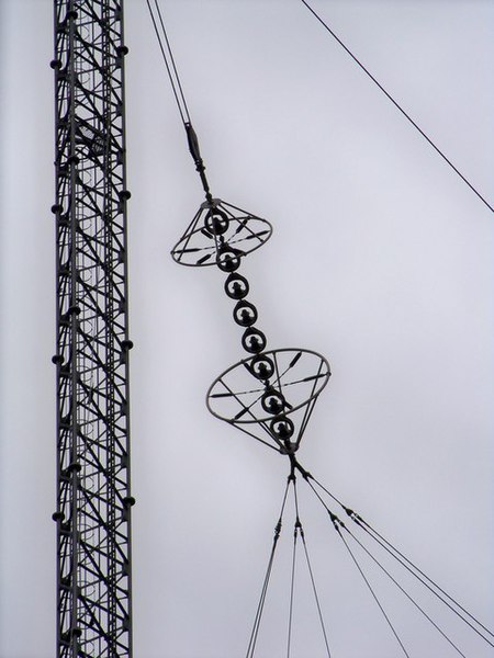
Insulator string on the large wire antenna of the naval VLF transmittter at Anthorn Radio Station, Anthorn, UK
Summary[edit]
| DescriptionAnthorn Transmitting Station Communications Masts - Cable Detail ^3 - geograph.org.uk - 1804403.jpg |
English: View of one of the high voltage insulator strings of the huge wire trideco antenna of the very low frequency (VLF) naval radio transmitter at Anthorn Radio Station, Anthorn, UK, used by the British Navy to communicate with submerged submarines. This facility was actually under the command of NATO, and in a nuclear war would be used to transmit missile launch orders to ballistic missile submarines. It transmits on 19.6 kHz with a callsign of GQD with output power of 550 kilowatts. The antenna consists of 6 vertical wire radiators surrounding the central mast, driven at the base of the mast. Each is attached at an insulator string like this to a 2148 foot long rhombic-shaped horizontal multiwire topload. The toploads extend at angles of 60° from the central mast, supported by 12 surrounding masts, giving the antenna the shape of a 6 pointed star when viewed from above. The entire antenna is more than a mile in diameter. The standing waves on the high Q antenna create very high voltages on the topload wires, requiring a long insulator string like this with corona rings at each end to stand the voltage. |
| Date | |
| Source | From geograph.org.uk |
| Author | James T M Towill |
| Attribution (required by the license) InfoField | James T M Towill / Anthorn Transmitting Station Communications Masts - Cable Detail #3 / |
InfoField | James T M Towill / Anthorn Transmitting Station Communications Masts - Cable Detail #3 |
| Camera location | 54° 54′ 16″ N, 3° 16′ 36″ W | View this and other nearby images on: OpenStreetMap |
|---|
| Object location | 54° 54′ 32″ N, 3° 16′ 30″ W | View this and other nearby images on: OpenStreetMap |
|---|
Licensing[edit]

|
This image was taken from the Geograph project collection. See this photograph's page on the Geograph website for the photographer's contact details. The copyright on this image is owned by James T M Towill and is licensed for reuse under the Creative Commons Attribution-ShareAlike 2.0 license.
|
This file is licensed under the Creative Commons Attribution-Share Alike 2.0 Generic license.
Attribution: James T M Towill
- You are free:
- to share – to copy, distribute and transmit the work
- to remix – to adapt the work
- Under the following conditions:
- attribution – You must give appropriate credit, provide a link to the license, and indicate if changes were made. You may do so in any reasonable manner, but not in any way that suggests the licensor endorses you or your use.
- share alike – If you remix, transform, or build upon the material, you must distribute your contributions under the same or compatible license as the original.
File history
Click on a date/time to view the file as it appeared at that time.
| Date/Time | Thumbnail | Dimensions | User | Comment | |
|---|---|---|---|---|---|
| current | 12:22, 14 March 2011 |  | 480 × 640 (55 KB) | GeographBot (talk | contribs) | == {{int:filedesc}} == {{Information |description={{en|1=Anthorn Transmitting Station Communications Masts - Cable Detail #3 A detailed view of cable arrangements in the site.}} |date=2010-04-08 |source=From [http://www.geograph.org.uk/photo/1804403 geogr |
You cannot overwrite this file.
File usage on Commons
There are no pages that use this file.
Metadata
This file contains additional information such as Exif metadata which may have been added by the digital camera, scanner, or software program used to create or digitize it. If the file has been modified from its original state, some details such as the timestamp may not fully reflect those of the original file. The timestamp is only as accurate as the clock in the camera, and it may be completely wrong.
| _error | 0 |
|---|