File:Atlas van het Hoogheemraadschap van Rijnland 001.jpg
Jump to navigation
Jump to search

Size of this preview: 451 × 600 pixels. Other resolutions: 180 × 240 pixels | 361 × 480 pixels | 577 × 768 pixels | 770 × 1,024 pixels | 1,540 × 2,048 pixels | 3,648 × 4,851 pixels.
Original file (3,648 × 4,851 pixels, file size: 1.9 MB, MIME type: image/jpeg)
Captions
Captions
Add a one-line explanation of what this file represents
Summary[edit]
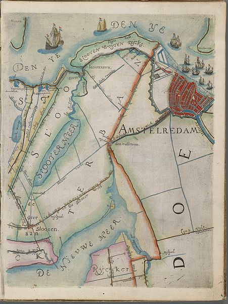
| Kaart van het hoogheemraadschap van Rijnland, Amsterdam, 1615. | ||||
|---|---|---|---|---|
| Author |
Floris Balthasarsz. van Berkenrode |
|||
| Title |
Kaart van het hoogheemraadschap van Rijnland, Amsterdam, 1615. |
|||
| Description |
Nederlands: Kaart van het hoogheemraadschap van Rijnland : Amsterdam, 1615. - Floris Balthasars vervaardigde deze overzichtskaart samen met zijn zoon Balthasar Florisz. van Berckenrode, in opdracht van dijkgraaf en hoogheemraden van Rijnland. De basis hiervoor waren de manuscriptkaarten van alle ambachten binnen Rijnland. Vanaf deze manuscriptkaarten graveerde Balthasars het hoogheemraadschap in twintig koperplaten. In 1614 verleende de Staten-Generaal hem octrooi op deze kaart voor de eerstvolgende tien jaren. - Dit kaartblad geeft weer Amsterdam en omgeving |
|||
| Date | 1615 | |||
| Dimensions | height: 41 cm (16.1 in); width: 31 cm (12.2 in) | |||
| Collection | Hoogheemraadschap van Rijnland | |||
| Accession number |
A-4066 |
|||
| Source/Photographer | Hoogheemraadschap van Rijnland : Afbeelding | |||
| Permission (Reusing this file) |
|
|||
File history
Click on a date/time to view the file as it appeared at that time.
| Date/Time | Thumbnail | Dimensions | User | Comment | |
|---|---|---|---|---|---|
| current | 10:25, 14 December 2015 | | 3,648 × 4,851 (1.9 MB) | Ralphstuyver (talk | contribs) | higher resolution |
| 22:25, 7 July 2010 |  | 811 × 1,044 (181 KB) | Vincent Steenberg (talk | contribs) | {{Information |Description={{nl|1=Atlas van het Hoogheemraadschap van Rijnland}} |Source=internet |Author={{Creator:Floris Balthasarsz. van Berckenrode}} |Date={{Other date|between|1610|1623}} |Permission= |other_versions= }} [[Category:Old maps of Amste |
You cannot overwrite this file.
File usage on Commons
The following page uses this file:
File usage on other wikis
The following other wikis use this file: