File:BEDROOM 2. VIEW FACING EAST - CAMP H.M. SMITH AND NAVY PUBLIC WORKS CENTER MANANA TITLE VII; (CAPEHART) HOUSING, THREE-BEDROOM SINGLE-FAMILY TYPE 7, Birch Circle, Elm Drive, Elm HABS HI-524-G-15.tif
Jump to navigation
Jump to search

Size of this JPG preview of this TIF file: 736 × 600 pixels. Other resolutions: 295 × 240 pixels | 589 × 480 pixels | 942 × 768 pixels | 1,257 × 1,024 pixels | 2,513 × 2,048 pixels | 5,242 × 4,272 pixels.
Original file (5,242 × 4,272 pixels, file size: 21.36 MB, MIME type: image/tiff)
Captions
Captions
Add a one-line explanation of what this file represents
Summary[edit]
| BEDROOM 2. VIEW FACING EAST - CAMP H.M. SMITH AND NAVY PUBLIC WORKS CENTER MANANA TITLE VII; (CAPEHART) HOUSING, THREE-BEDROOM SINGLE-FAMILY TYPE 7, Birch Circle, Elm Drive, Elm Circle, and Date Drive, Pearl City, Honolulu County, HI | ||||
|---|---|---|---|---|
| Photographer |
Franzen, David |
|||
| Title |
BEDROOM 2. VIEW FACING EAST - CAMP H.M. SMITH AND NAVY PUBLIC WORKS CENTER MANANA TITLE VII; (CAPEHART) HOUSING, THREE-BEDROOM SINGLE-FAMILY TYPE 7, Birch Circle, Elm Drive, Elm Circle, and Date Drive, Pearl City, Honolulu County, HI |
|||
| Depicted place | Hawaii; Honolulu County; Pearl City | |||
| Date | 2006 | |||
| Dimensions | 4 x 5 in. | |||
| Current location |
Library of Congress Prints and Photographs Division Washington, D.C. 20540 USA http://hdl.loc.gov/loc.pnp/pp.print |
|||
| Accession number |
HABS HI-524-G-15 |
|||
| Credit line |
|
|||
| Notes |
|
|||
| Source | https://www.loc.gov/pictures/item/hi0833.photos.367602p | |||
| Permission (Reusing this file) |
|
|||

| Object location | | View this and other nearby images on: OpenStreetMap |
|---|
File history
Click on a date/time to view the file as it appeared at that time.
| Date/Time | Thumbnail | Dimensions | User | Comment | |
|---|---|---|---|---|---|
| current | 03:06, 13 July 2014 | 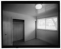 | 5,242 × 4,272 (21.36 MB) | Fæ (talk | contribs) | GWToolset: Creating mediafile for Fæ. HABS 11 July 2014 (1001:1200) |
You cannot overwrite this file.
File usage on Commons
The following page uses this file: