File:Base of phoenix column at western end of rolling mill. - Phoenix Iron Company, Rolling Mill, North of French Creek, west of Fairview Avenue, Phoenixville, Chester County, PA HAER PA,15-PHOEN,4C-18.tif
Jump to navigation
Jump to search
Size of this JPG preview of this TIF file: 429 × 600 pixels. Other resolutions: 172 × 240 pixels | 343 × 480 pixels | 549 × 768 pixels | 732 × 1,024 pixels | 1,465 × 2,048 pixels | 3,576 × 5,000 pixels.
Original file (3,576 × 5,000 pixels, file size: 17.05 MB, MIME type: image/tiff)
Captions
Captions
Add a one-line explanation of what this file represents
Summary[edit]
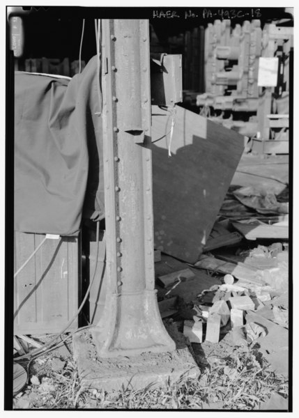
| Base of phoenix column at western end of rolling mill. - Phoenix Iron Company, Rolling Mill, North of French Creek, west of Fairview Avenue, Phoenixville, Chester County, PA | ||||
|---|---|---|---|---|
| Photographer |
Lowe, Jet |
|||
| Title |
Base of phoenix column at western end of rolling mill. - Phoenix Iron Company, Rolling Mill, North of French Creek, west of Fairview Avenue, Phoenixville, Chester County, PA |
|||
| Description |
DeLony, Eric N, project manager; Pennsylvania Department of Transportation, sponsor; Pennsylvania Historical and Museum Commission, sponsor; Lowe, Jet, photographer |
|||
| Depicted place | Pennsylvania; Chester County; Phoenixville | |||
| Date | 1999 | |||
| Dimensions | height: 7 in (17.7 cm); width: 5 in (12.7 cm) | |||
| Current location |
Library of Congress Prints and Photographs Division Washington, D.C. 20540 USA http://hdl.loc.gov/loc.pnp/pp.print |
|||
| Accession number |
HAER PA,15-PHOEN,4C-18 |
|||
| Credit line |
|
|||
| Notes |
|
|||
| Source | https://www.loc.gov/pictures/item/pa3841.photos.362500p | |||
| Permission (Reusing this file) |
|
|||

| Object location | | View this and other nearby images on: OpenStreetMap |
|---|
File history
Click on a date/time to view the file as it appeared at that time.
| Date/Time | Thumbnail | Dimensions | User | Comment | |
|---|---|---|---|---|---|
| current | 06:49, 1 August 2014 |  | 3,576 × 5,000 (17.05 MB) | Fæ (talk | contribs) | GWToolset: Creating mediafile for Fæ. HABS 31 July 2014 (3000:3200) |
You cannot overwrite this file.
File usage on Commons
The following page uses this file: